Environmental Engineering Reference
In-Depth Information
Evidence of detailed site analysis appeared
during the development of Hadrian's Villa, at
Tivoli near Rome, around 117 BC. Evidence
shows that climatic factors, such as wind di-
rection and solar access, along with such site
factors as orientation, views, and slope aspect
were all considered by the emperor in his de-
sign of the Villa complex as a means to maxi-
mize the enjoyment of the spaces and the sur-
rounding natural environment (Moore 1960).
More than 2,200 years later, the site analy-
sis process underwent a major advancement
when landscape architect Ian McHarg, at
the University of Pennsylvania, introduced
his graphical method for interpreting mul-
tiple environmental factors and their influ-
ence in decision-making processes (McHarg
1969). McHarg's method was the first time
environmental designers could assemble
key site data elements in a uniform format
that allowed for easy interpretation and
decision making. This uniform method or
technique has been further refined with the
use of geographic information system (GIS)
computer software. Several publications
introduce restoration project site analysis
(Harris, Birch, and Palmer 1996; Zentner
1994; Packard and Mutel 1997; Bradshaw
and Chadwick 1980; Anderson and Ohmart
1985; Daigle and Havinga 1996) but do not
discuss the process of using the data in de-
veloping a restoration plan.
The ideal site analysis process will focus
on identifying the factors or elements that
have the greatest potential to influence the
outcome of your restoration strategies.
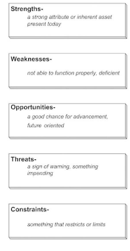
FIGURE 4-2.
Each factor from the site analysis
process is assigned a category and is used for site
evaluation and refinement of project goals and
objectives.
Collecting Project Site Data
Once you have determined the type of data to collect, the time you have to collect it, the number
of people and the skills required to collect it, then you are ready for data collection.
Search WWH ::

Custom Search