Geoscience Reference
In-Depth Information
•
Create the small scale Administrative Units polygon datasets from the
simplified Administrative borders dataset utilizing the point dataset with
the areas' attributes.
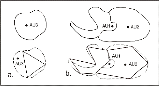
The last procedure can sometimes create several attribute errors (e.g.
wrong code, no data etc). Since the geometry of the Administrative borders
has changed due to simplification, the point that holds the attributes of the
original polygon will not always fall inside the new generalised polygon.
For example, if the point falls outside the polygon in the case of an island,
same generalised polygon the wrong attributes may be attached to this
polygon whereas “null” attribute values are attached to the adjacent poly-
Figure 4:
Possible errors caused by Scenario 1
Scenario 2:
Apply generalisation to the polygon dataset and then recreate
the linear dataset. The geographic objects to be modeled and generalised
are the Administrative Units. One of the main constraints in the generalisa-
tion of a polygon dataset is the minimum area in relation to scale. Such a
requirement cannot be applied when the generalisation is performed at the
borders level. In case that the minimum area requirement is applied to the
polygons that are created from the generalised lines and a polygon is
deleted, this change in geometry cannot be transferred to the borders dataset
because the linear and the polygon datasets are independent. As a result the
two datasets will be inconsistent. In contrast to this when generalisation is
performed at the polygon level, minimum area requirements can be applied
along with other generalisation requirements related to the borders such as
level of detail, which can be handled by simplification. Afterwards, linear
data consistent with the polygons can be created.