Geoscience Reference
In-Depth Information
•
The topological and position constraints: spatial relationships and rela-
tive distances between objects must be maintained.
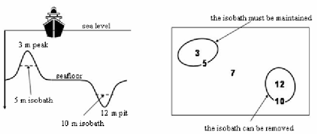
Figure 1:
Illustration of the safety constraint
The first two constraints are the most important and must be satisfied for
the chart to be valied. The safety constraint imposing rules on the selection
and displacement of lines, specific operators must be defined. Guilbert and
Saux (2008) defined a smoothing operator which pushes the line in one
direction. This method is based on a snake model and takes into account the
proximity between neighboring lines. It also prevents the creation of self
intersections in the deformation process. The authors applied the method
together with other operations (selection, aggregation and contour interrup-
tion) however the application of an operation has to be confirmed by the
user as the algorithm does not possess enough information about the con-
text to make its own decision. The required information is mostly related
to the type of feature the isobath belongs to and its relation with other
features.
Other constraints are related to the preservation of terrain features. Mor-
phological information is useful for the navigator to locate his position
based on surrounding landmarks and seabed information returned by sonar
especially in shallow and coastal areas. They are less important than the
first two constraints and are used to evaluate the quality of the chart. They
refer to the amount of deformation applied to lines and the preservation of
topological relationships between features and lines.