Geoscience Reference
In-Depth Information
Both the input and output data models for the feature classes representing
flowing waters (rivers and canals) have a simple semantic, comprising
only the attributes id, name and hydrography class (a code to differ
between the types of rivers or canals based on their width). The flow direc-
tion is not present in the data models and this required reconstructing it
from other data.
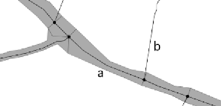
Figure 1:
the hydrography network is divided into sections having areal geometry (a) or
linear geometry (b).
The differences between the two data models arise comparing the specifi-
cations of each feature class. In the input data model (GeoDBR) water-
courses are classified only into 2 hydrography class: “narrow” watercourses,
represented as a single line, and “broad” watercourses, those wider than 1
meter, represented both with a single line and an area. In the output data
model (DB25), they are divided in four hydrography classes: “very small”,
“small”, “medium” and “large” watercourses, respectively with width
being less than 1 meter, from 1 to 5 meters, from 5 to 20 meters, more than
20 meters; all of them are represented with a line and only the latter class
is represented also by an area. As a further specification, the IGMI data
model imposes a minimum river and canal length of 250 meters.
1.2 Objectives
Comparing the input and output data models and their specifications, it
was clear that the generalization process for the hydrography should pur-
sue two objectives:
•
to find a way to classify the watercourses based on their width;