Geoscience Reference
In-Depth Information
area computed as part of the enrichment process aids the choice of which
reach to add to the master centerline list.
Once false candidates are removed, the correctly identified set of candidate
reaches is moved to the master centerline list and removed from the candi-
date list.
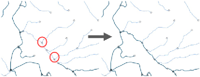
Figure 4:
Inset of a portion of Pomme de Terre subbasin geometry shown at 1:15,000. The
circles represent nodes in the stream network. The left panel shows a gap of more than
two reaches between centerlines. Red circles highlight two confluences where false can-
didate reaches must be eliminated, as discussed in the text. The panel at right shows the
solution of the centerline delineation, eliminating false candidate reaches.
During the algorithm design, it was noticed that in some cases, reach code
numbering tends to follow in a spatial sequence. For example, if two ex-
tracted centerline segments have reach codes 001 and 005, and the center-
line formed by these two contains a gap, the reaches connecting the gap
might be numbered 002, 003 and 004. Furthermore, if reaches branch off
the centerline in this vicinity, those reach code values tend to be much lar-
ger or much smaller. A reduced-search strategy used a range delimiter to
assess which of the alternative reach codes would more likely fill in the
centerline gap.
And so in cases where a centerline gap was discovered to span more than
two reaches, stream channels exhibiting a range of successive reach code
values were considered (i.e., a “candidate series”), instead of scanning the
full set of remaining candidate reaches. These candidate series were then
iteratively dissolved and each group tested to see if the dissolved feature's
nodes were coincidental with endnodes of any centerline gap. This shortcut
worked for the Missouri subbasin, but was found to operate incorrectly for