Geoscience Reference
In-Depth Information
1- Introduction
Nowadays, the co-existence of many and heterogeneous geographic data-
bases covering the same area, implies to study how these data/metadata
should be integrated in order to avoid duplicated results on the screen. In-
teroperability is the key aspect to elaborate in such situation. It is defined
by OGC as the “capability to communicate, execute programs, or transfer
data among various functional units in a manner that requires the user to
have little or no knowledge of the unique characteristics of those units”
(OpenGIS, 1996).
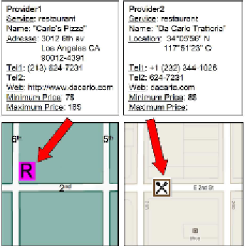
At the application level, a motivating example, as shown in the figure1 be-
low, had inspired us to direct our study towards a major problem which is
related to location and cartographic integration of same geo-located service
from many providers. Let us consider a user's request to find the nearest
restaurant in his area. First of all, he might encounter the answer of an
American restaurant listed by two different providers, not exactly located
at the same place (50 meters of difference). The same restaurant is named
“the Roadster Diner” in the first one and “Roadster” in the second one,
with few differences in their semantic details and represented differently as
cartographic symbols (icons) on different proprietary base maps. This in-
consistency in spatial and non-spatial information from both providers is a
fact and we must know how to deal with it in order to visualize both as the
same integrated object.
Figure 1:
Example of the same LBS restaurant from two providers (candidates for integra-
tion)