Geoscience Reference
In-Depth Information
Figure 12:
Channel representation in
BDTOPO
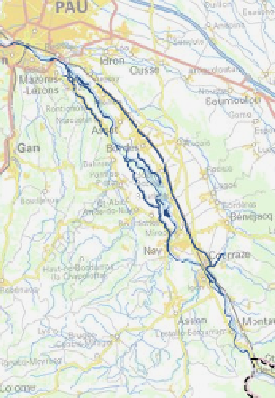
Figure 13:
Channel representation in
BDCARTO
4- Conclusion and perspectives
We proposed in this paper an ontology-based system for discovering
geographic databases content. The use of ontologies in this context is a
promising approach to facilitate the discovery of geographic data in the
web. The proposed system allows a better comprehension of the
geographic databases content, thanks to the formalization and an
appropriate display of their specifications coupled with a web mapping
solution allowing a visual comparison of the data of interest. The
implemented prototype of the system using data from the IGN shows the
feasibility and usefulness of the approach for geodata understanding and
comparison. In the future, we plan to improve the system with respect to
several aspects.
For expressing his/her need, the user has actually the possibility to select
one concept's name from the topographic domain ontology. It would be
interesting to allow her/him to select more than one concept's name in
order to be able to compare data representing different geographic entities.