Geoscience Reference
In-Depth Information
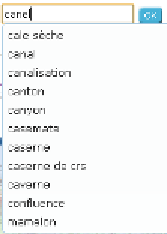
In order to take into account typos when the user enters his/her query, the
system computes a distance between the typed string and the concepts
names in the domain topographic ontology, using the
Levenshtein
edit
distance (Levenshtein 1965) which was normalized in our system using the
method proposed in (Yujian 2007). This way, the closest concepts' labels
will be proposed to the user. For example, if the user types '
canel
' instead
of '
canal
' (which means channel in French), then the system will still find
'canal' as illustrated on
figure 7
.
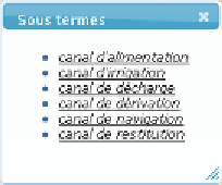
The system also allows the user to refine
her/his query by proposing to her/him terms designating concepts that are
specializations of the concept '
canal
' in the topographic ontology as shown
on the
figure 8
.
Figure 7:
auto-completion system
Figure 8:
terms for query refining
The information extraction module extracts from the specification
ontologies, information about the data referred to by the term specified by
the user. In the case of 'canal' the system will extract information about
precise localizations of channels in the databases and other information
like the type of geometry of channels in the database (polygons or
polylines). All those pieces of information are sent to the user and
display is organized in an accordion composed of four sections.
The first section (
figure 9
) indicates which features of the database refer to
the term selected by the user: it describes how these features are
represented in one or several classes, and with which attribute values they
are modeled. Here, channels are described in two different classes
'
water_surface
' and 'watercourse', that may be shown to the user, and
objects representing channels in the class '
watercourse
' have in particular
the specific attribute value '
artificial = true
', which allows to distinguish
them from natural watercourses.