Geoscience Reference
In-Depth Information
the features that were retained from the interview. Finally, there is a
detailed discussion of how to implement QGIS-MT.
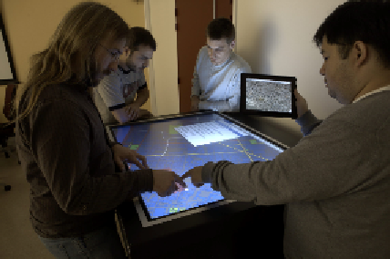
Figure 1:
A group discusses the implantation of street furniture
2- Interactive and Collaborative Setup
Collaborative work is often necessary in GIS. For instance, major emer-
gency events like natural disasters, industrial accidents or terrorist attacks
require a timely and a coordinated response effort from a number of differ-
ent experts (e.g. a GIS expert, a cartographer, an urban planner, etc.).
Collaborative GIS can also be useful to share skills with less experienced
users (such as managers or politicians) or to communicate with the public.
Some studies have proposed to augment GIS by providing remote or
co-located collaborative capabilities to overcome the limitations of the
classical mono-user paradigm. After presenting them briefly, we will describe
our own interactive and collaborative setup.
2.1 Remote GIS
With the increase of broadband connectivity and data storage on DMBS,
most GIS (such as ArcGIS) allow several users to work on the same data
set, but only one user could modify a vector data at a given time by means
of a system of locks (Vretanos 2005). GroupArc (Churcher et al. 1996) en-
ables several users to interact on the same vector layer, but only one user