Geoscience Reference
In-Depth Information
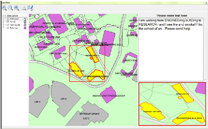
Figure 2:
Screen capture from Geoparsing Tool showing a geographic selection from a text
entry as keyed to the localized gazetteer
The geoparsing tool accepts text entries and generates a list of all possible
strings associated with placenames in a localized gazetteer. Concerns
regarding insufficient or inaccurate text-entry, such as character case, special
characters, and duplicates are accounted for in the processing used in the
tool. Intensive testing for text entry errors and special cases has signifi-
cantly improved the association rate of text entries to locations in the local-
ized gazetteer. Geoparsing of the data pinpoints the geographical feature
placenames with location coordinates for further spatial analysis (Hill
2008). The tool then identifies those features on a geographically refer-
enced map, displayed using the MapWindow OCX control. Added func-
tions for the tool include capturing the path between the spatial features
identified in the localized gazetteer, and parsing useful distances and direc-
tions from texted propositions, modifiers and cardinal directions, such as
near, towards, or north.
As mentioned, we use a localized gazetteer to match text-based or voice-
based descriptions containing placenames associated with observations to
a spatial footprint. Our localized gazetteer is built using a data model,
structured on concepts from Hill (2006). The gazetteer data model contains
items of primary interest to blind individuals navigating through the local
environment; namely, buildings, roads, walkways, parking lots, and land-
data model for buildings.
Table 1
contains entries for feature naming char-