Geoscience Reference
In-Depth Information
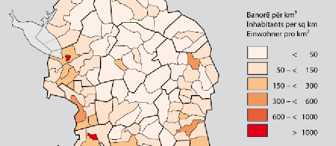
Figure 4:
A typical choropleth atlas map: population density 2001 (detail). Source: Demo-
graphic Atlas of Albania (Bërxholi et al. 2003).
The
map type module
specifies the exemplary population density map as a
thematic map which is made up of a map theme and a base map stack. The
map theme stack comprises an array of cards of which the density card is
applicable here. The relevant thematic element of that card is population
density. Likewise, the relevant element of the base map card is boundaries.
The attributes relevant here fall into two categories: natural boundaries,
such as the land-water boundary, and administrative boundaries, such as
state, provincial, district and communal boundaries.
The
data module
includes geometry, attribute, and behaviour stacks. The
relevant card of the attribute stack, linked to the theme card, is that of
quantitative data. This card contains qualitative data and quantitative data
elements of which the latter is selected. In the geometry stack the relevant
card is discrete data which is subdivided into point, line and area data
elements of which the latter two are selected and linked to the theme card
and base map card, respectively.
The
processing module
comprises map scale, data modelling and graphics
modelling stacks. In the map scale stack, the small scale card is selected.
The data modelling stack includes scaling and classification cards. The
scaling card contains nominal, ordinal and metric elements of which the
latter is applicable. For map compilation the metric data modelling element
is linked to the area data element of the geometry data stack. In the graphics
modelling stack the card selected is the generalisation card which includes
scale-oriented and theme-oriented elements. The theme-oriented element is
selected for generalisation and linked to the population density card as well
as to the boundaries element of the base map card.