Environmental Engineering Reference
In-Depth Information
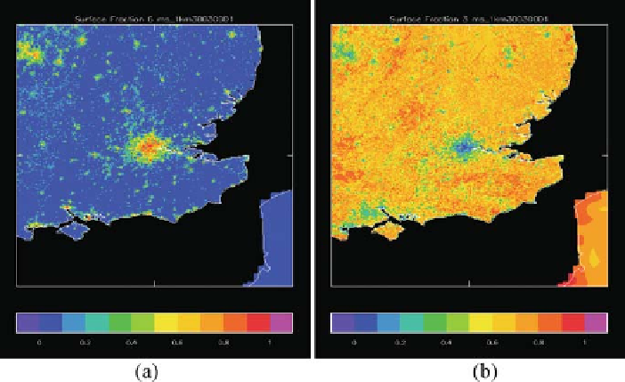
Fig. 9.1
Land-use fraction at 1 km resolution over SE England (centred on London) derived from
CEH data
(a)
urban
(b)
C3 grass (i.e. grass and crops) (See also Colour Plate 12 on page 176)
provides single category data at
1 km resolution except over Great Britain, where
CEH (Landsat-based) data are used ( http://www.ceh.ac.uk/). The latter has 25 m
resolution with two urban categories (urban and dense urban). Figure 9.1 shows an
example from a 1 km configuration of the UM.
≈
9.3 The Urban Tile, Thermal Canopy, Roughness Lengths
for Heat and Anthropogenic Heat Flux
The urban tile was originally implemented simply through modification of tile
properties such as albedo, roughness, drainage, canopy capacity, etc. This might
be termed the 'rough concrete' approach, in that no explicit account is taken of
the morphology of urban areas. This approach to urbanization has been taken in
a number of models historically, as it requires no structural change to the model,
only parameter changes. The approach has positive impacts, in that reduced wind
speeds and enhanced surface fluxes with enhanced turbulence being reproduced, but
the approach still leads to significant errors in the thermal response to the diurnal
cycle, especially in the evening transition period. This is, in part, due to difficulties
in reproducing the thermal behaviour of the surface. The UM has a further issue
because, while the surface is tiled, the sub-surface ('soil') is not (yet). Even if a
'concrete soil' worked well, this could not be combined with the vegetation tiles
within the same grid box.
Some of these problems have been overcome by including a 'thermal canopy' in
the surface energy balance (SEB) (Best, 2005) which mimics, in a very simple way,
Search WWH ::

Custom Search