Environmental Engineering Reference
In-Depth Information
a
)
b)
Overall area
Natural surfaces
600
600
400
400
200
200
0
0
-200
-200
0
000
0
600
1200
1800
2400
0000
0600
1200
1800
2400
Time (UTC)
Time (UTC)
Street canyons
c)
d)
Roofs
600
600
400
400
200
200
0
0
-200
-200
0
000
0
600
1200
1800
2400
0000
0600
1200
1800
2400
Time (UTC)
Time (UTC)
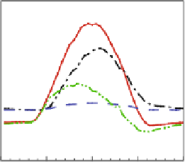
Fig. 6.4
Average simulated energy budget components of Marseille city center, for the overall
footprint (
a
), the natural surfaces (
b
), the roofs (
c
), and the paved surfaces (
d
)
solid line
,net
radiation flux;
dashed line
, latent heat flux;
dash-dot line
, sensible heat flux;
dash-dot-dot line
,
(storage) conduction heat flux
thermodynamic properties (Long, 2003; Long and Kergomard, 2005). The method
has been made available to the FUMAPEX participants (Mestayer et al., 2004, 2006;
Baklanov and Mestayer, 2004; Baklanov et al., 2005, 2008).
SM2U has been coupled with the atmospheric model MM5 by Dupont et al.
(2004) to simulate Philadelphia. This urbanized version of MM5 is freely available
at the US EPA, has been used by, at least, the groups from ARL/NOAA (J. Ching),
NCAR (F. Chen) and CORIA (A. Coppalle), and further developed by Bornstein
et al. (2006). It has also been coupled with ARPS/SUBMESO (Leroyer, 2006), with
HIRLAM for the Copenhagen area (Mahura et al., 2005), and with WRF (Chen
et al., 2006).
Leroyer et al. (2006, 2009) used the Large Eddy Simulation model
ARPS/SUBMESO with SM2U to study the dynamic structure of the boundary layer
in the case of a coastal city, where the urban, coastal, and orographic influences are
in competition. This study included simulations of simplified configurations and
a further analysis of the data obtained in Marseille during a UBL-ESCOMPTE


Search WWH ::

Custom Search