Environmental Engineering Reference
In-Depth Information
This framework allows for analysis by the scientific community by providing an effi-
cient means of sharing observed and modelled data. The community provides the
means for detailed analysis and knowledge integration. The data-sharing concept
in NUDAPT can facilitate research efforts to improve models of the urban envi-
ronment. For example, if a researcher wishes to compare their model results with
another simulation that used a different set of UCPs. This is easily accomplished
by querying the database, retrieving the model run of interest, and analysing the
results at the user end. Once researchers utilize these UCPs in their modelling, more
knowledge integration will occur through enhanced model evaluations leading to
improved models.
Datasets will either reside on the NUDAPT portal server or, where available for
public download elsewhere, the portal will provide a link to facilitate the appropri-
ate download. Because the site is expected to act as a data repository rather than
an active transaction-heavy database, there does not appear to be a need to utilize
database software to manage the datasets in question. Instead the datasets will exist
as stand-alone files in the file system. The initial Prototype will use the ArcGIS 9.2
server that provides the desired functionality needed to handle both vector and raster
data formats.
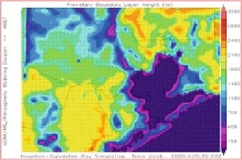
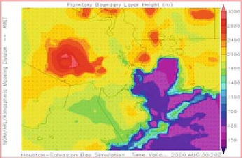
1.4 Discussion and Summary
Initial sensitivity studies of air quality (and other) applications using outputs of
advanced meteorological models that incorporate NUDAPT type data are being per-
formed. Figure 1.2 contrasts the mixed layer simulations from MM5 with and with-
out UCP. The urban area of Houston is categorized with one urban land use category
in the standard version of MM5. Figure 1.3 illustrates the sensitivity of the Commu-
nity Multiscale Air Quality (CMAQ) modelling system to MM5 versions with and
without detailed urban canopy features. In this instance, significant differences are
seen, serving as a motivation for advancements in urban modelling.
(a)
(b)
Fig. 1.2
Simulations of mixed layer heights size for 2100 GMT on August 30, 2000 using MM5
with
(a)
UCP and
(b)
standard version of MM5 at 1 km grid (See also Colour Plate 2 on page 171)
Search WWH ::

Custom Search