Environmental Engineering Reference
In-Depth Information
meteorological and air quality models. Additionally, ancillary information such as
gridded population, energy usage and traffic will be incorporated to encourage and
facilitate linkages to air quality and human exposure models. An important core-
design feature is the portal technology to enable NUDAPT to be a “Community”
based system. Web-based portal technology will facilitate data retrievals and han-
dling based on data federation concepts. Houston, Texas is the NUDAPT's initial
prototype. Advanced urban canopy implementations of the MM5 and WRF are used
to demonstrate the NUDAPT features, including scope of the data and processing
methodologies for an eventual extensibility to all other cities.
1.2 Approach
In this paper, we describe a prototype of an operational template that can be
extended to provide an eventual nation-wide capability that will serve a broad user
community engaged to develop and drive powerful new and advanced atmospheric
transport and dispersion and air quality modelling tools. Already, the value of using
high resolution urban data in meteorological and air quality simulations has been
demonstrated from sensitivity studies based on mesoscale modelling system that
incorporate urban canopy parameters (Ching et al., 2004; Dupont et al., 2004; Chen
et al., 2006). This will provide a strategic implementation to both the modelling
and decision support communities requiring appropriate modelling tools to support
the assessments and applications required to reduce the health risks associated with
exposure to air of poor quality. Further, it addresses homeland security in regard to
transport and dispersion of toxic releases.
Houston, the fourth largest city in the USA, was selected to serve as the ini-
tial prototype to demonstrate the NUDAPT features. For this city there are lidar-
derived building data with unrestricted use (Fig. 1.1) and air quality data from major
(a)
(b)
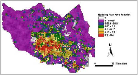
Fig. 1.1
1 km section of down-
town Houston.
(b)
Building plan area density, an example of a UCP for Harris County (Houston
Metropolitan area) (cf. Table 1.1) (See also Colour Plate 1 on page 171)
(a)
3D building data derived from airborne lidar platform for 1
×

Search WWH ::

Custom Search