Agriculture Reference
In-Depth Information
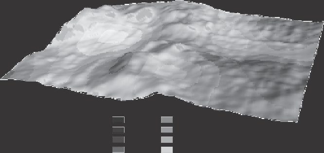
Soil depth (mm)
< 300
300 - 350
350 - 400
400 - 450
450 - 500
500 - 550
550 - 600
> 600
Figure 1.15
Three-dimensional map showing surface topography and soil depth in a 7.3 ha
vineyard in the Coonawarra region, South Australia. (Map courtesy of Dr. Robert Bramley,
CSIRO Ecosystems Sciences, Adelaide, South Australia.)
which spatially referenced soil data are stored in virtual layers, along with informa-
tion on field boundaries, streams, and roads, and are linked to attribute data that
describe each spatial feature in the GIS.
The raw sensor output can be manipulated to produce a map showing the
spatial variability in soil in the area surveyed, without knowing the cause of the
variability. With this information, the surveyor can decide on the best placement
of inspection pits to encompass the full range of soil variability. However, in order
to understand the meaning of this variation in terms of a soil property of interest,
the sensor output must be converted to actual values of the property by calibration
against laboratory-measured values, as in the case of clay content or salinity (see
“Texture Analysis and Calibration for Texture,” chapter 2), or by using a model of
soil chemical reactions, as in the case of estimating a soil's lime requirement (see
box 3.6, chapter 3). Once a calibration relationship is established, spatially refer-
enced data can be collected over adjacent areas, stored in a GIS, and used directly
without the need for filtering through a soil classification. Provided proper cali-
brations are established, data for soil depth, soil texture, permeability, salinity, and
so on can be used to plan the layout of a new vineyard, including the allocation of
individual varieties to particular sites and the design of an irrigation system.
Even in established vineyards, more precise knowledge of soil variation
enables pruning, irrigation, fertilizing, and mulching to be carried out on a
zonal basis, where a zone is an area in which the soil is less variable than in
the vineyard as a whole. Note that the boundaries between zones in an estab-
lished vineyard may or may not coincide with those between vineyard blocks.
Because soil variation can be correlated with vine vigor, fruit yield, and quality,