Geology Reference
In-Depth Information
In a
paleomagnetic reference frame,
the
z
-axis
always coincides with the apparent directions of
the Earth's spin axis as determined by a se-
these frames, the longitude of a point is relative
to an arbitrarily selected location on a reference
continent. For example, if the central African
craton is chosen to be the reference continent,
then we could select a reference site in central
Africa and assign to this location a fixed longi-
tude coinciding with the present day value. This
approach can be found in Besse and Courtillot
(
1988
). Other more complex techniques assign
a changing longitude (in the paleomagnetic ref-
erence frame) to the reference site according to
specific algorithms (e.g., Schettino and Scotese
2005
), but in any case the longitude of any other
point is referred to this site and not to the Green-
wich meridian.
The second broad class of reference frames is
represented by
local coordinate systems
,which
have the following common features: (
a
)the
origin is an observation point at the Earth's sur-
face (seismic station, magnetic field measurement
point, etc.); (
b
)the
z
-axis is aligned with the
vertical to the observation point (plumb line), so
that the
xy
plane is a tangent plane to the Earth's
surface. These reference frames are usually em-
ployed to represent the geometry of faults, focal
mechanisms of earthquakes, and magnetic field
measurements, but they can be used to charac-
terize any local vector or tensor quantity of geo-
physical interest (Cox and Hart
1986
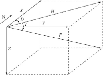
). Figure
2.3
illustrates the conventions used in geomagnetism,
where the
z
-axis is directed downwards, the
x
-
axis is directed northwards, and the
y
-axis is
directed eastwards. In this instance, the Earth's
core field vector,
F
, can be represented by three
Cartesian components (
X
,
Y
,
Z
) or, alternatively by
its
declination
,
D
,byan
inclination
,
I
,anda
magnitude,
F
.
From Fig.
2.3
, we see that the equations of
transformation from (
F
,
D
,
I
)to(
X
,
Y
,
Z
)are:
8
<
Fig. 2.3
Local Cartesian components of the Earth's main
field,
F
(
X
,
Y
,
Z
) and horizontal component,
H
. The dec-
lination,
D
, is the azimuth of
H
, while the inclination,
I
is
the angle between
F
and
H
, positive downward
D
The inverse transformation can be easily ob-
tained from these expressions. It follows that:
8
<
:
D
D
arctan.Y=X/
I
D
ar
csin .Z=F/
F
D
(2.30)
p
X
2
C
Y
2
C
Z
2
Finally, form th
e definitio
n of horizontal com-
ponent, H
D
p
X
2
C
Y
2
, it follows that the
inclination can be also expressed as a function of
Z
and
H
:
I
D
arctan .Z=H/
(2.31)
We emphasize that although these equations
refer to the specific case of the geomagnetic field,
they can be used to express the components of
any other vector quantity in a local coordinate
system at the Earth's surface.
2.4
Plate Boundaries
Three fundamental kinds of plate boundaries can
be observed in the oceanic domain, which have
three counterparts in continental areas. In the
oceans, we find mid-ocean ridges, trenches, and
strike-slip faults. The continental analogues of
these tectonic structures are, respectively, rifts,
collision zones, and transcurrent faults. Now we
X
D
F cos I cosD
Y
D
F cosI sin D
Z
D
F sin I
(2.29)
: