Geology Reference
In-Depth Information
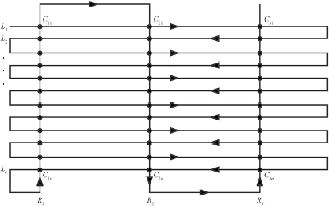
Fig. 5.4
Example of
marine or aeromagnetic
survey pattern (
black line
),
formed by 12 survey lines,
L
i
, and 3 tie lines,
R
k
.
Crossover points,
C
ik
,are
shown as black dots
exclusively with ionospheric and magnetospheric
activity. In fact, at the time scale of a magnetic
survey (a few days) secular variations can
be neglected. Alternatively, if a magnetic
observatory exists at reasonable distance (within
a few tens km), it is possible to use the total
field intensity magnetogram of that station to
perform the diurnal correction. These data can be
easily downloaded from the
Intermagnet
network
at
http://www.intermagnet.org
.
The procedure
is simple. Let
T
0
D
T
0
(
t
) be a base-station
magnetogram with 1 s sampling rate and
T
k
D
T
(
r
k
,
t
k
) the observed total field intensities at
locations
r
k
at times
t
k
(
k
D
1,2, :::,
n
). Then, the
sequence corrected for external field variations
can be obtained applying the transformation:
according to geological considerations, and some
transverse
tie lines
(Fig.
5.4
).
The idea is to have duplicate measurements at
some stations, which are called
crossover points
.
A crossover point is placed at the intersection
between a survey line and a tie line. The differ-
ence between the two readings gives information
about the diurnal variations of the geomagnetic
field, as we shall see in the next section. In this
instance, the correction for external field daily
variations requires a special algorithm, and the
pre-processing of raw data will consist essentially
into the removal of
spikes
, either manually or
through a filtering procedure, and into the
paral-
lax correction
, which adjusts the data coordinates
to take into account for the sensor offset relative
to the ship (or to the airplane).
Although most modern marine magnetic
surveys are made using the criteria described
above, many “historical” surveys across the
World's oceans, made during the 1960s and
1970s, are simply long ship tracks that cross
the oceanic basins from one continental margin
to the opposite margin. In some cases these data
were taken during magnetic storms, and there is
no way to remove the contribution of the external
fields. Therefore, it is necessary to be cautious
when using these data in plate kinematics. The
minimum pre-processing work consists into a
recalculation of the magnetic anomalies, starting
T
k
!
T
k
ŒT
0
.t
k
/
T
0
.t
1
/
T
k
T
0
.t
k
/
I
k
D
1;2;:::;n
(5.5)
This procedure can be also applied to aero-
magnetic surveys on continental regions. It only
requires a series of base-station magnetometers
placed at fixed locations in the survey area. In
absence of these additional magnetometers, or
in the case of oceanic surveys far away from
continental margins, a different procedure must
be used. In this instance, the track line is formed
by a series of
survey lines
, which are oriented