Environmental Engineering Reference
In-Depth Information
In the depositional zone, the gradient lattens from a buildup of sediment over time. The river
widens further and meanders toward its mouth. Near the mouth, the meanders and the separate
channels that are formed may make the determination of the main channel problematic.
2.2.1.1 Drainage Basins and Networks
These same three zones (headwater, transfer, and depositional zones) can also be seen on a smaller
scale within the watersheds of contributing streams. One deinition of a watershed is the “area of
land that drains water, sediment, and dissolved materials to a common outlet at some point along a
stream channel” (Dunne and Leopold 1978). The size and structure of watersheds as well as their
topographic and geographic structures vary signiicantly due to geologic, morphologic, vegetative,
soil, and climatic differences. Their form varies greatly due to the climatic regime and the underly-
ing geology, morphology, soils, vegetation, etc. Drainage patterns are primarily controlled by the
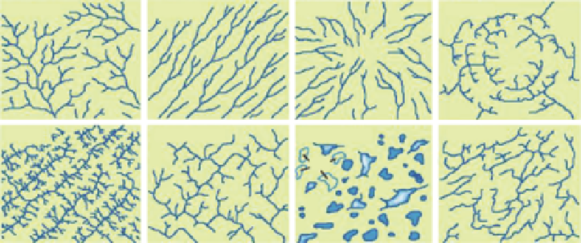
overall topography and underlying geologic structure. Figure 2.6 illustrates some of the common
patterns.
2.2.1.2 Stream Order
The characteristics of rivers and streams may also be inluenced, and illustrated, by their connectivity.
As a stream or river forms in a watershed, lowing along the path of least resistance, it eventually
meets and merges with other rivers or streams to form yet larger rivers or streams, resulting in the
planform view, their connectivity like the branches of a tree.
A method of classifying the hierarchy of natural channels according to their position in the drain-
age system, referred to as
stream order
, (Figure 2.7) permits a comparison of the behavior of a river
with others similarly situated. The original method for characterizing rivers by their connectivity
was developed by Horton (1945) and the most commonly referenced modiication is that proposed by
Strahler (1957). In that classiication, small headwater streams are designated Order I. Streams formed
by the conluence of two Order I streams are referred to as Order II, and so on, with larger numbers
indicating larger rivers with multiple tributary streams. The scheme has proven useful for develop-
ing and testing generalizations and predictions about river processes. For example, as previously dis-
cussed, a stream is associated with the river gradient, drainage area, channel width, and discharge.
Note that a second-order stream is formed by the conluence of two irst-order streams and so on,
while the intersection of a stream with a lower-order stream does not raise the stream order (e.g., a
third-order stream intersecting with a irst-order stream is still a third-order stream below the inter-
section). In general, the number of rivers or streams decreases nearly exponentially, and the stream
Dendritic
Parallel
Radial
Annular
Trellis
Rectangular
Multibasinal
Contorted
Dry
FIGURE 2.6
Watershed drainage patterns. (From Howard, A.D.,
AAPG Bulletin Series
, 51, 2246-2259,
1967. Reprinted from American Association of Petroleum Geologists and Datapage, Inc. With permission.)
Search WWH ::

Custom Search