Environmental Engineering Reference
In-Depth Information
Reservoir operation, or water level management, strategies are typically incorporated into guide
or rule curves, water control diagrams, with the goal of managing the reservoir to follow, as closely
as practicable, these guide curves. The guide or rule curve is a seasonally varying plot of water-
surface elevations (which translates to storage), depicted as either a line or an envelope, developed to
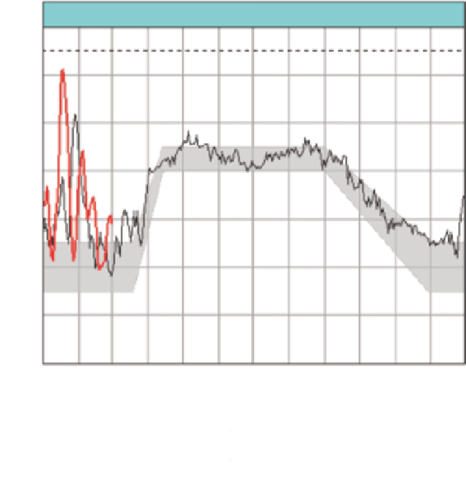
relect how the reservoir is to be managed. Figure 10.5 illustrates a guide curve for Pickwick Lake.
The shaded area is the normal operation (for power production and summer mosquito control), the
top of which may be exceeded for the regulation of lood lows.
Kennedy et al. (2000) conducted a categorical evaluation of the guide curves used in the U.S.
Army Corps of Engineers reservoirs, as illustrated in Figure 10.6. Case (a) is typical of reservoirs
operated for navigational purposes, where a constant water-surface elevation is desirable. Examples
include the reservoirs on the Tennessee Tombigbee Waterway and Old Hickory on the Cumberland
River. Cases (b) and (c) illustrate a rule or guide curve commonly associated with a hydropower
project (e.g., see Figure 10.5), where there is an elevated summer conservation or hydropower pool
and the project is operated between an upper and a lower limit. Cases (d) and (e) are commonly
associated with lood control (Figure 10.6). Case (f) is where the pool could be depleted during
portions of the year due to demands such as irrigation, maintaining minimum releases, water sup-
ply, and other consumptive uses (Kennedy et al. 2000). Cases (g) and (h) are for “dry dams” to
Pickwick operating guide
419
To p of gates: 418
Latest midnight elevation: 410.8
417
415
413
411
409
407
405
Jan eb
Mar
AprMay
JunJul
2013
Aug ep
Oct
Nov
Dec
03/03/2013
2013 observed midnight elevations
2012 observed midnight elevations
Normal operating zone
FIGURE 10.5
Guide curve for Pickwick Lake comparing the desired operating envelope (gray area) to the
actual lake-water surface elevations for 2012 (black line) and portions of 2013 (red line). (From Tennessee
Valley Authority. Pickwick operating guide. Knoxville, TN. Available at: http://www.tva.gov/river/lakeinfo/
op_guides/pickwick.htm.)


Search WWH ::

Custom Search