Environmental Engineering Reference
In-Depth Information
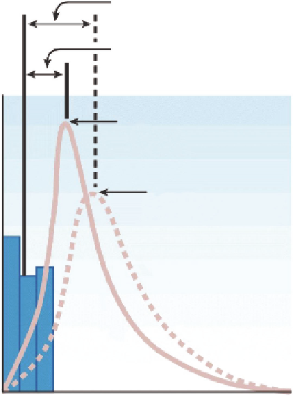
Lag time before
urbanization
Lag time after
urbanization
Q after
Q before
Time (h)
FIGURE 4.3
Comparison of hydrographs before and after urbanization. (From FISRWG,
Stream Corridor
Restoration: Principles, Processes, and Practices
, Federal Interagency Stream Restoration Working Group,
1998.)
when rain does not occur, the low from groundwater discharge or other inlow processes may make
up the base low. When rain does occur, rain falling on the portion of the watershed closest to the outlet
runs off irst, and rain falling on the most hydraulically distant part of the watershed will run off last.
If rain continues to fall at the same magnitude, the runoff hydrograph will continue to increase (rising
limb of the hydrograph). If rainfall continues to fall at the same rate, then the runoff would be constant
as equilibrium is reached between the rainfall and runoff. Many of the simple methods for predicting
runoff are based on the prediction of that peak equilibrium low. When the rain stops, then the runoff
will gradually return to the base low, which is the falling limb of the hydrograph. However, in reality,
for large watersheds, the shape of the hydrograph will depend on the shape of the basin, its land uses,
and other factors impacting runoff, as well as the shape of the rainfall hyetograph. Also, watersheds
are not static and changes in land uses, such as urbanization, can change the magnitude of the peak
runoff and the shape of the hydrograph, as illustrated in Figure 4.3. A variety of techniques are avail-
able to estimate the runoff magnitude and duration as a function of watershed characteristics and these
techniques are summarized in any good topic on water resources engineering (e.g., Wurbs and James
2002) or hydrology (e.g., Bedient and Huber 2008).
4.3
STAGES OF MEASURING FLOW
4.3.1 L
ocatIon
, L
ocatIon
, L
ocatIon
The irst step in measuring lows is to identify a suitable measurement location. The site should be
accessible, for example, and, of course, it should represent a location where low measurements are
needed. The location could be different depending on the intended use of those measurements.
Search WWH ::

Custom Search