Graphics Programs Reference
In-Depth Information
OnewaytousethistoolforeffectiveprojectcoordinationistosettheProject
Base Point in your template to
0,0,0
, which is the default location in the
project templates provided with the software. If all consultants utilize these
settings, it will be easier to keep the models in alignment.
You also have the option to acquire the coordinates of a linked file. Use
the Coordinates tool on the Project Location panel of the Manage tab, and
select the Acquire Coordinates option. This allows you to select a linked
file in the drawing area and sets your project coordinates to match those
of the linked file.
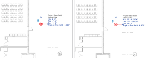
Figure 4.7
shows (left) the settings for a project prior to
acquiring coordinates and (right) the settings after the coordinates of the
linkedmodelareacquired. Thisensuresthatbothfilesareworking offofthe
same coordinate system. Notice that the Project Base Point is in the same
location in relation to the building geometry.
Figure 4.7
Settings before acquiring coordinates (left) and after acquiring
coordinates (right)
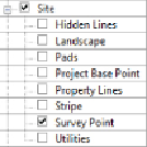
The
survey point
of a project can be used to define a real-world coordinate
point within a project. The survey point can be made visible by using the
Visibility/Graphic Overrides dialog box, as shown in
Figure 4.8
.
Figure 4.8
Survey Point visibility settings
The survey point shows as a triangle in the view. Moving a “clipped” survey
point changes the position of the shared coordinate system in relation to
the model and the project coordinate system. So, for example, if you have