Travel Reference
In-Depth Information
Left
Park Naturel Régional des Boucles de la Seine Normande
Right
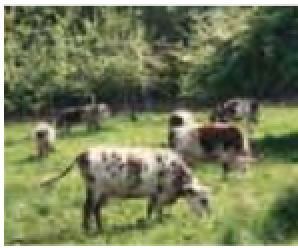
La Suisse Normande
Areas of Natural Beauty
La Suisse Normande
Centred around the River
Orne, this region of gentle hills,
rocky cliffs, woods and charming
villages is hardly reminiscent of
Switzerland, but still attracts its
share of hikers and tourists.
Well placed for exploring, the
capital Clécy is also a centre for
climbing, canoeing and hang-
gliding
(see p88)
.
Pays d'Auge
Pays d'Auge
When most people think of
Normandy, they picture apple
orchards, manor houses, rolling
hills, hedgerows, meadows
where brown and white cows
graze, timbered farmhouses. This
“typical Normandy” is the Pays
d'Auge, the rural hinterland to the
glamorous Côte Fleurie, and home
to cider, Calvados and some of
France's most famous cheeses,
including Camembert. It is also
home to Ste Thérèse of Lisieux,
a long tradition of horse breeding,
and a type of rice pudding called
teurgoule (see pp32-3)
.
Parc Naturel Régional des
Boucles de la Seine
Normande
Following the snaking loops
(boucles)
of the Seine, this 580
sq km (224 sq mile) park wedged
between Rouen and Le Havre
was originally known as the Parc
Naturel Régional de Brotonne. It
embraces forests (notably the
Forest of Brotonne), orchards,
pastures and the Marais Vernier
wetlands. It is also the starting
point for the Fruit and Cottage
Routes.
d
Map H3
•
Maison du Parc:
Notre-Dame-de-Bliquetuit. 02 35 37 23 16
Parc Naturel Régional de
Normandie-Maine
Normandy's largest regional park
spans 2,350 sq km (900 sq
miles) of Basse-Normandie and
Pays de la Loire, with scenery
that ranges from deep forests
to gently rolling hills, and from
marshlands to meadows. The
park aims to preserve rural
traditions by promoting local arts
and crafts, agriculture, forestry
and outdoor activities
(see p108)
.
Pays de Caux
42