Environmental Engineering Reference
In-Depth Information
Failure
Proportional limit
Safe
= 0
= 0
= 0
7000
6000
5000
4000
3000
2000
1000
50 100 250
600
50 100 250
600
50 100 250
600
P
c psi (
3
)
P
c psi (
3
)
P
c psi (
3
)
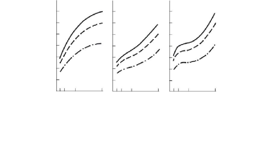
FIGURE 10.12
Triaxial compression tests results from coal specimens. (From Ko, A.Y. and Gerstle, K.H.,
Proceedings of ASCE,
14th Symposium on Rock Mechanics,
University Park, PA, 1973, pp. 157-188. With permission.)
subsidence history, and mining operations beneath the site. Many states and municipali-
ties have extensive catalogs of abandoned mine maps. For example, the Ohio Division of
Geological Survey has maps for 4138 mines, most of which are coal mines.
If possible, data on mining operations beneath the site should be obtained from the min-
ing company that performed the extraction. The data should include information on the
mine limits, percent extraction, depth or depths of seams, pillar dimensions, and the clo-
sure date. Other important data that may be available include pillar conditions, roof and
floor conditions, flooding incidence, the amount of collapse that has already occurred, and
accessibility to the mine.
Explorations
Exploration scopes
will vary depending upon the comprehensiveness of the existing data
and the accessibility of the mine for examination. Actual inspection of mine conditions is
extremely important, but often not possible in old mines.
Preliminary explorations
where mine locations and collapse conditions are unknown or
uncertain may include the use of:
Gravimeters to detect anomalies indicating openings.
●
Rotary probes, if closely spaced, to detect cavities and indicate collapse conditions.
●
Borehole cameras to photograph conditions, and borehole TV cameras, some of
which are equipped with a zoom lens with an attached high-intensity light, to
inspect mines remotely.
●
Acoustical emissions devices, where mines are in an active collapse state, to
locate the collapse area and monitor its growth.
●
Electrical resistivity using the pole-dipole method
(Section 2.3.2)
was used in a
study in Scranton, Pennsylvania, where the abandoned coal seam was 45 to 75 ft
below the surface. Three signatures were interpreted (
Figure 2.33);
intact rock,
caved rock, and voids. Test borings confirmed the interpretations.
●