Environmental Engineering Reference
In-Depth Information
that sent data to the base station which included a radio modem, personal computer con-
nected to a phone line or the Internet for graphical output. The massive block at the head
of the landslide was found initially to be moving at less than 1cm/week, then accelerating
to 2 cm/week apparently in response to rainfall. At the cessation of seasonal rains it
remained moving at the rate of 1 mm/week for a 4-month period from February to June
2000. GPS measurements were reported to typically show repeatability
±
1 cm horizontally
and
±
2 cm vertically.
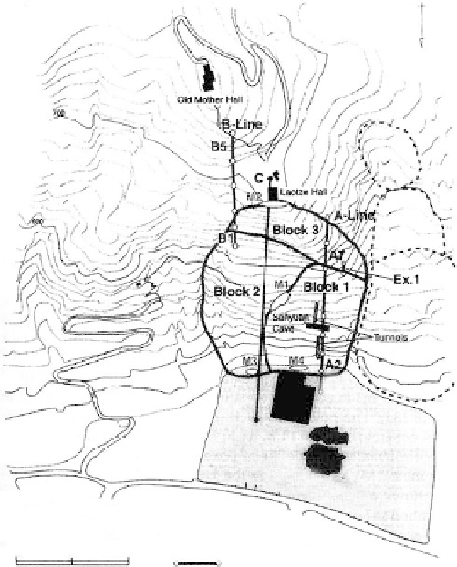
Lishan Slope, Xian, China
Orense (2003) describes the landslide hazard threatening the Huaqing Palace, in Xian,
China. Built during the Tang dynasty (618-907), the Palace is located at the foot of the
Lishan slope that shows visible deformation. The potential failure mass is a large-scale
rock slide. Although in an area of earthquake activity, it is believed that subsidence in the
valley from extensive groundwater withdrawal has resulted in activating slope move-
ments. Geologic conditions generally consist of a layer of loess overlying gneiss bedrock.
A site plan is given in
Figure 9.134.
The potential failure mass has been divided into three
possible blocks. The dashed line represents the limits of a thick loess deposit that has
already slid.
Studies were begun in 1991 by the Disaster Prevention Institute of Kyoto University,
Japan, and the Xian Municipal Government. An extensive automated monitoring system
was installed as shown in
Figure 9.135.
Included in the system were short- and long-span
extensometers (lines A and B, Figure 9.134), total station surveying, GPS survey, borehole
inclinometers, and ground motion seismographs. Data are transmitted periodically to
Kyoto University via satellite.
N
FIGURE 9.134
Plan map of the Lishan slope in China
with potential landslide blocks and
extensometer lines (From Orense, R.P.,
Geotechnical Hazards: Nature, Assessment
and Mitigation,
University of the
Philippines Press, Ouezon City, 2003.
With permission. After Sassa, K. et al.,
Proceedings of the International Symposium
on Landslide Hazard Assessment,
1-24,
Xian, China, 1997.)
500
A1
C'
0
100
200 m
Extensometer line