Environmental Engineering Reference
In-Depth Information
3500
Zone A
Zone B
3000
Zone
Danger levels, %
A
B
C
D
100
67
31
0
Zone C
2500
2000
Zone D
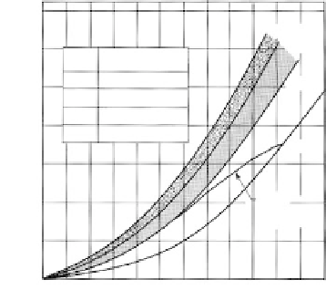
FIGURE 9.95
Correlation between rainfall and landslides (Serra de
Caraguatatuba, São Paulo, Brazil). Chart based on rainfall
record station No. E2-65-DAEE, installed in May 6, 1928,
in the town of Caraguatatuba. Mean annual precipitation
of 1905 mm based on 46 year record. Approximate station
elevation of 10 m. (From Guidicini, G. and Iwasa, O.Y.,
Bull.
Int. Assoc. Eng. Geol.,
16, 13-20, 1977. With permission.)
1500
Mean
cumilative
precipitation
1000
500
0
Jul.
A
S
O
N
D
J
F
M
A
M
Jun.
tions drier than normal and there have been no major storms, it can be stated that the slope
has
not
been tested under severe weather conditions. It may be concluded that it is not nec-
essarily a potentially stable slope. If a cut is failing under conditions of normal rainfall, it
can be concluded that it will certainly undergo total failure at some future date during
more severe conditions.
Case 1
: In a study of slope failures on the island of Sumatra, examination was made of
several high, steep slopes cut in colluvium which were subjected to debris and slump
slides during construction. Failure occurred during a normal rainy season of 500 mm (20
in.) for the month of occurrence. The cuts were reshaped with some benching and flatter
inclinations and have remained stable for a year of near-normal rainfall of about 2500 mm
(98 in.) with monthly variations from 80 to 673 mm (3 to 26 in.).
Rainfall records were available during the study for only a 5-year period, but during the
year before the cuts were made 1685 mm (66 in.) were reported for the month of December
during monsoon storms. The cuts cannot be considered stable until subjected to a rainfall
of this magnitude, unless there is an error in the data or the storm was a very unusual
occurrence. Neither condition appears to be the case for the geographic location.
Case 2
: A number of examples have been given of slope failures along the Rio Santos
Highway that passes through the coastal mountains of Brazil. Numerous cuts were made
in the years 1974 and 1975 without retention, and a large number of relatively small slides
and other failures have occurred. The solution to the problem adapted by the highway
department, in most cases, is to allow the failures and subsequently clean up the roadway.
As of 1980, except for short periods, during the slide illustrated in
Figure 9.93,
the road has
remained in service.
A review of the rainfall records for the region during the past 40 years (from 1984)
revealed that the last decade had been a relatively dry period with rainfall averaging
about 1500 to 2000 mm (59 to 79 in.). During the previous 30 years, however, the annual
rainfall averaged 2500 to 3500 mm (98 to 138 in.). One storm in the period dropped 678
mm (27 in.) in 3 days (see
Section 9.2.8)
.
In view of the already unstable conditions along
the roadway, if the weather cycle changes from the currently dry epoch to the wetter cycle
of the previous epoch, a marked increase in incidence and magnitude of slope failures can
be anticipated.
Temperatures
Freezing temperatures and the occurrence of frost in soil or rock slopes are highly signifi-
cant. Ground frost can wedge loose rock blocks and cause falls, or in the spring months
can block normal seepage, resulting in high water pressures which cause falls, debris ava-