Environmental Engineering Reference
In-Depth Information
300
0
300
600
900
Scale in feet
Cucaracha slide
East culebra slide
West culebra slide
Panama canal
location of major
slide areas
Old town of culebra as it existed in
1909 superimposed on slide limits
and topography exisisting in
March 1947
FIGURE 9.34
Plan view of slides and topography, Culebra Cut, Panama Canal. (From Binger, W.V.,
Proceedings of the 2nd
International Conference on Soil Mechanics and Foundation Engineering
, Rotterdam, Vol. 2, 1948, pp. 54-60. With
permission.)
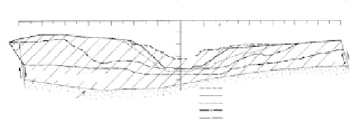
Feet
cL
Station 1782 +50
East
West
1200
1000
800
600
400
200
200
400
600
800
1000
1200
1400
1400
400
300
200
100
0
Fault
Fault
Cucaracha formation
Surface existing prior to american excavation
January 1912
Culebra formation
June 1912
July 1915
March 1947
FIGURE 9.35
Sketch of east and west Culebra slides (Panama Canal) showing progress of slide movement: Cucaracha
tuffaceous shale and Culebra tuffaceous shale, siltstone, and sandstone. (From Binger, W.V.,
Proceedings of the
2nd International Conference on Soil Mechanics and Foundation Engineering
, Rotterdom, Vol. 2, 1948, pp. 54-60.
With permission.)
Coastal Plain Sediments: Portuguese Bend Slide
Event
: At Portuguese Bend, Palos Verdes Hills, California (see
Figure 10.3
for location), a
slide complex with a maximum width of roughly 4000 ft and a head-to-toe length of about
4600 ft began moving significantly in 1956 and as of 1984, was still moving. Coastal plain
sediments are involved, primarily marine shales. This slide may be classified as progres-
sive block glides or failure by lateral spreading. It is one of the most studied active slides
in the United States (Jahns and Vonder Linden, 1973).
Physiography
: The limit of the slide area is shown in
Figure 9.36,
and the irregular hum-
mocky topography is shown on the stereo-pair of aerial photos in
Figure 9.37.
In the slide