Environmental Engineering Reference
In-Depth Information
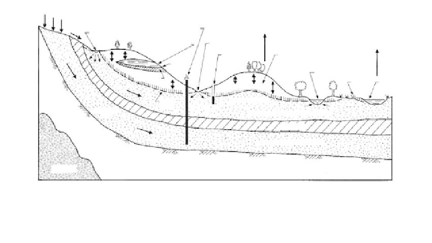
Precipitation
(recharge area)
Runoff
Artesian well
Perched
groundwater
Transpiration
Influent stream
Influent stream
Evaporation
Gravity
well
Zone of aeration
(radose water)
Spring
Effluent stream
Aquiclude
Swamp
Lake
Capillary fringe
Saturated zone
Unconfined aquifer (free water)
Water
table
Infiltration
flow
Aquiclude
Artesian (confined) water
Aquifuge
Aquiclude
FIGURE 8.18
Cross section illustrating the occurrence of groundwater.
rise above the reservoir level. The height of the rise varies inversely with the
radius of the tube, which may be likened to the interstices of soil masses. In
coarse gravels, the rise is insignificant and in clean sands it is in the order of a
few inches to a few feet. The rise increases substantially as the percentage of fines
increases. In predominantly clayey soils, capillary rise occurs very slowly but
can be as high as 25 ft or more. Capillary rise for various gradations is given in
Table 3.10.
Capillary rise provides the moisture that results in the heaving of
buildings and pavements from the volume increase of expansive soils or from
freezing, or the destruction of pavements from “pumping” under wheel loads
where pavement support is provided by fine-grained soils. The potential for the
detrimental effects of capillary rise is a function of soil type and the depth of the
static groundwater table, or a perched water table.
Seasonal High Groundwater
has been defined by the NJDEP (1989) for subsurface
sewage disposal systems based on soil mottling. “Where mottling is observed, at
any season of the year, the seasonally high groundwater table shall be taken as
the highest level at which mottling is observed, except when the water table is
observed at a level higher than the level of the mottling.” Mottling is defined as
“a color pattern observed in soil consisting of blotches or spots of contrasting
color.” Hunt (1972) refers to mottling as occurring in poorly drained soils that
remain wet for significant periods; colors are greys and browns (USDA, 1951). It
is not expected that “mottling” would be apparent in free-draining soils.
●
Saturated Zone (Free-Water Zone)
Phreatic surface
is the static water level (or table, “GWT”), at which the neutral
stress
●
µ
w
in the soil equals zero. In coarse-grained soils, it is approximately the
interface between the saturated and unsaturated zones.
Confined water
occurs in the free-water zone, but is bounded by impervious or
confining strata.
●
Aquifer
refers to a formation which contains water and transmits it from one
point to another in quantities sufficient to permit economic development.
Although a geologic definition, the term is used by engineers to designate a
water-bearing stratum.
Specific yield
is the amount of water that can be obtained
●