Environmental Engineering Reference
In-Depth Information
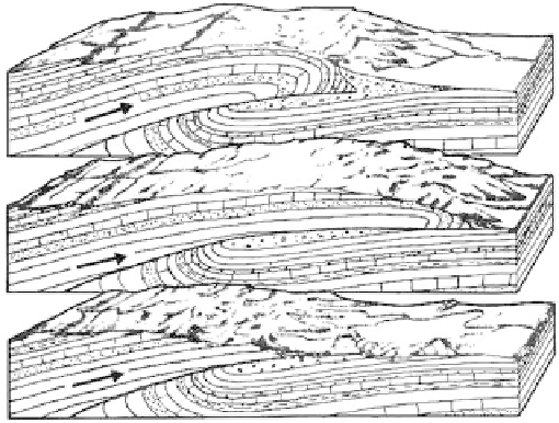
FIGURE 6.52
The stages of development of a thrust
fault or overthrust.
6.5.3
Characteristics and Identification
Surface Evidence
Surface evidence of faulting is given by lineations, landforms, drainage features, second-
ary features, and seismological data as summarized and described in
Table 6.8.
Some char-
acteristic landforms are illustrated in
Figure 6.53.
Internal Evidence
Internal evidence, as disclosed by borings and excavations, is given by stratum discontinu-
ity, slickensides, fault zone materials (breccia) gouge, mineral alteration, groundwater levels,
and foliation and mylonite shear zones as summarized and described in
Table 6.9.
Examples
of slickensides are given in
Figure 6.54
and
Figure 6.55,
various kinds of fault fillings in
Figure 6.56,
and some effects of the circulation of hydrothermal solutions along faults in
Normal and Thrust Faults
The Ramapo fault of northern New Jersey is an example of normal faulting and a tilted
fault block. The Ramapo River flows along the contact between the Precambrian crystalline
rocks in the western highlands and the Triassic lowlands in the east as shown in
Figure 6.59.
The steep slopes on the western side of the river are the fault scarp; blocked drainage and
sag ponds are apparent on the easterly lowlands as shown on the topographic map. The
area is shown also in the satellite images given in
Figure 2.5
and
Figure 6.29.
The characteristics of thrust and normal faults during initial displacement are illustrated
in
Figure 6.60.
Block diagrams illustrating the surface features of a normal- and a reverse-
slip fault after substantial displacement are given in
Figure 6.61.
A thrust fault is also illus-
trated in
Figure 6.62.
Strike Slip or Wrench Faults
The San Andreas fault is the best-known example of a strike-slip fault. Located parallel to
the coastline in southern California (see
Figure 11.9),
it is almost 600 mi (1000 km) in length
and extends vertically to a depth of at least 20 mi (30 km) beneath the surface. Along with
branch faults and other major faults, it is clearly evident as strong lineations on the satel-
lite image given in
Figure 6.63.