Environmental Engineering Reference
In-Depth Information
In a more common logic, GIS-applications allow users to analyse spatial infor-
mation, edit data (aggregation, generalization, and projection are most typical
editing actions), create maps, perform logical or spatial queries, and present the
results of all these operations in maps or tables.
From the application-oriented view, GIS is an information platform used as a
interface to obtain thematic maps, which have to be distinguished from the under-
lying software providing tools for the management of spatial data. In this sense,
modellers are developers, picking methods and resources from GIS-applications
and using them as a toolbox.
By providing data management, (statistical) analysis and visualization tools, GIS
were among the first frameworks that made wide-ranging methods of integration
available.
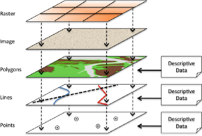
Capturing spatial data in GIS follows the general idea shown in Fig.
22.2
.
Graphical layers or
features
, which could be entities with a geographic location,
consisting of vector structures like points, lines, polygons, any kind of raster-files or
objects from a database model, are tied to a geodetic coordinate system, defining
their position (see Derby et al. 2005). The relevant descriptive records are linked to
the features by unique identifiers.
Using geographical information for integration enables modelling with precise
spatial data and condensing respective results in maps (Livingstobe et al. 1994).
This is advantageous since information in maps is spatially referenced. GIS can
Fig. 22.2 General structure of GIS: geo-position as connection between different layers of data.
Vector data (
polygons, lines, points
) are linked to attribute tables with descriptive data (modified
from Derby et al. 2005)