Environmental Engineering Reference
In-Depth Information
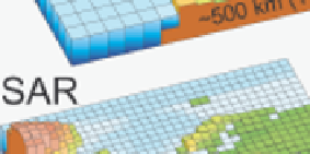
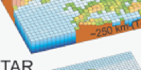
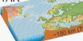
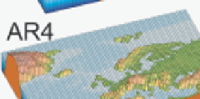
Figure 2.5.2
Geographic resolution used in the climate models
Geographic resolution used in the climate models for the different IPCC reports: FAR
(IPCC, 1990), SAR (IPCC, 1996), TAR (IPCC, 2001a), and AR4 (2007). The fi gures show
the resolution of northern Europe. The vertical resolution in both atmosphere and ocean
models has increased comparably with the horizontal resolution, beginning typically
with a single-layer slab ocean and ten atmospheric layers in the FAR and progressing
to about thirty levels in both atmosphere and ocean.
Figure from IPCC, reproduced with
permission
[2.2].


Search WWH ::

Custom Search