Environmental Engineering Reference
In-Depth Information
500 km
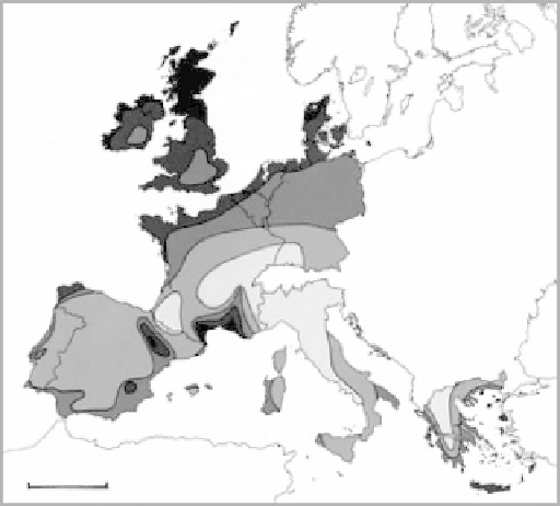
FIGURE 4.3
European wind resources at 50 m above ground level for five different topographic conditions. (From
I. Troen and E. L. Petersen,
European Wind Atlas
, Riso National Laboratory, Denmark, 1989. With permission.)
4.2 EUROPEAN UNION
The Europeans have a concentrated effort on wind resource assessment beginning with the publica-
tion of the
European Wind Atlas
[12] in 1989. Part 1 provides an overall view of the wind resources.
Part 2 provides information for determining the wind resource and the local siting of wind turbines.
It provides descriptions and statistics for the 220 met stations in the countries of the European
Community (EC) and includes methods for calculating the influence on the wind due to landscape
features such as coastlines, forests, hills, and buildings. Part 3 explains the meteorological back-
ground and analysis for the
European Wind Atlas
, and includes the physical and statistical bases for
the models. This wind map for the EC (Figure 4.3) shows high winds for northern United Kingdom
and Denmark and across the northern coasts from Spain to Denmark. Also, wind maps are available
for the thirteen countries. The wind power classes are somewhat different from those of the United
States, and they also include different terrain (Table 4.2). Since then the EC has expanded and is
now the European Union, and there are wind maps available for more countries.
TABLE 4.2
Wind Classes for Different Terrains,
European Wind Atlas
Shelter Terrain
Open Plain
Sea Coast
Open Sea
Hills and Ridges
Class
m/s
W/m
2
m/s
W/m
2
m/s
W/m
2
m/s
W/m
2
m/s
W/m
2
5
6.0
250
7.5
500
8.5
700
9.0
800
11.5
1,800
4
5.0-6.0
150-250
6.5-7.5
300-500
7.0-8.5
400-700
8.0-9.0
600-800
10.0-11.5
1,200-1,800
3
4.5-5.0
100-150
5.5-6.5
200-300
6.0-7.0
250-400
7.0-8.0
400-600
8.5-10.0
700-1,200
2
3.5-4.5
50-100
4.5-5.5
100-200
5.0-6.0
150-250
5.5-7.0
200-400
7.0-8.5
400-700
1
<50
3.5
4.5
100
5.0
150
5.5
200
7.0
400


Search WWH ::

Custom Search