Geoscience Reference
In-Depth Information
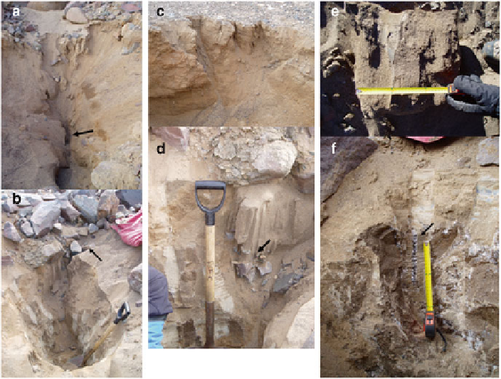
Fig. 5.7
Cryodesiccation in Beacon Valley, Antarctica as refl ected by (
a
) a sand wedge with a
contraction fi ssure (
arrow
); (
b
) an exposed fi ssure (
arrow
) surrounded by ice-bonded permafrost;
(
c
) a series of inactive fi ssures (
arrows
) from cryodesiccation; (
d
) vertical laminations of sand as
columns on stones (
arrow
) in a sand wedge; (
e
) a lateral view of rivulets of fl owing sand along a
contraction cracks; and (
f
) ice veins (
arrow
) in fi ssures of a sand wedge (Bockheim et al.
2009
)
5.3
Cryopedologic Processes and Soil Classifi cation
All of the soil classifi cation schemes developed for polar regions utilize cryopedo-
genic processes in some fashion. Tedrow (
1973
) viewed soil development and pat-
terned ground formation as “separate entities.” However, he recognized certain
relationships between the two. Tedrow's (
1973
) zonal scheme had four levels of
classifi cation that did not included patterned ground. For future detailed soil map-
ping, Tedrow left open the idea of using both the genetic soil and a variety of pat-
terned ground.
As will be seen in Chap.
6
, the soil classifi cation systems developed in the USA
and Canada and by the WRB all divide cryosols/gelisols using cryoturbation at the
highest level. In Russia soil with strongly cryoturbated horizons are classifi ed as
cryozems (Sokolov et al.
1997
).