Global Positioning System Reference
In-Depth Information
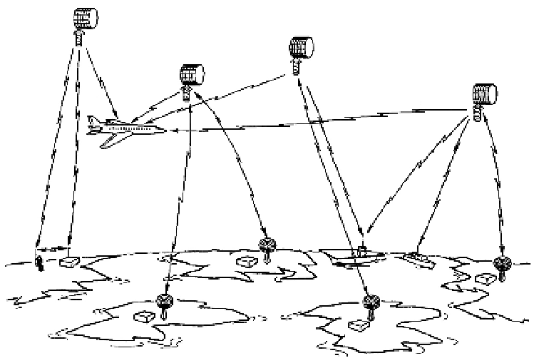
Fig. 4.2. Illustration of an airplane using Timation signals. This sketch from page 10 of the
Timation Development Plan
shows users on land, at sea, and in the air. The system was config-
ured to provide position (three dimensions) and velocity accuracy to within fifty feet for stra-
tegic and tactical aircraft, when using four satellites. (Courtesy Naval Research Laboratory)
In April 1973 Deputy Secretary of Defense William P. Clements issued a
memorandum creating the Defense Navigation Satellite Development Plan
(dnsdp), a joint Army, Navy, Marine Corps, and Air Force program. He desig-
nated the Air Force as the executive service and directed it to assign a program
manager and establish a joint program office ( jpo). He listed the following
guidelines for the program. Clements directed the Air Force to deploy during
1977 a constellation of four synchronous repeater navigation experimental
satellites (nes). This was a 621b constellation. He directed the Navy to launch
in 1974 the medium-altitude Navigation Technology Satellite #1 (renamed
nts-1; this was the satellite formerly designated Timation III). The secretary's
memo requested a decision coordinating paper, a formal system design plan,
by August 1973.
Navy captain David C. Holmes, a friend of John Glenn's, joined the Naval
Research Laboratory in early 1973 as a consultant working on Space Surveil-
lance and Timation. His important role in developing gps has been largely
ignored. A humorous story Holmes told gives one the sense of nrl's ethos:
Search WWH ::

Custom Search