Environmental Engineering Reference
In-Depth Information
Land Quality
The holistic concept of land as a natural resource was recognized in the Framework for
Land Evaluation (FAO 1976), repeated implicitly in Chapter 12 of the UN Conference on the
Environment and Development (UNCED) in 1992, and formally described in FAO 1995. It
reads: 'Land is a delineable area of the Earth's terrestrial surface, encompassing all attributes of
the biosphere immediately above or below this surface, including those of the near-surface cli-
mate, the soil and terrain forms, the surface hydrology (including shallow lakes, rivers, marshes
and swamps), the near-surface sedimentary layers and associated groundwater reserve, the
plant and animal populations, the human settlement pattern and physical results of past and
present human activity (terracing, water storage or drainage structures, roads, buildings, etc.).'
Land quality (or its lack) is a complex land attribute. It is not an absolute value, but has to
be assessed in relation to land functions and the specific land use that one has in mind. The
Land Use
As a space for any human activity, land is a resource
sui generis
. It is literally the founda-
tion for all economic activity and for all life, limited only by the extent of the Earth's sur-
face. This means that alternative patterns of land use, the predominant purpose for which
an area is utilized, are mutually exclusive. Intended alternative patterns of land use are
reflected in the spatial planning of governments. Accordingly, an understanding of land
use planning of the area in which the ore body is located is crucial at the very outset of
mine planning. In some jurisdictions such as Indonesia, if mining conflicts with existing
official land use plans (termed Spatial Plans), mine development can only commence after
the spatial plans have been adjusted to accommodate mining activities.
From an ecological point of view, we distinguish protective use (areas left to nature, e.g.
primary forest or wetlands), productive use (e.g. agricultural land or mining), and sterile
use (e.g. urban areas, housing, buildings, or utility/transportation corridors such as roads
or pipeline corridors). Environmental assessments sometimes overlook land required for
human activity, raising the potential for major conflict associated with alternative land uses.
An understanding of land use
planning of the area in which the
ore body is located is crucial at
the very outset of mine planning.
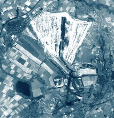
CASE 7.2
Coal Mining in Germany
Mining in Germany goes back a long time. This rich his-
tory is refl ected in the names of entire mountain ranges
such as Erzgebirge (ore mountains) and townships such
as Stolberg (tunnel mountain). Today, the German mining
industry has disappeared with the notable exception of
large-scale surface coal mining in the State of North Rhine
Westfalen, and a few government subsidized hard coal
under ground mines. The photograph shows a simulated
natural colour ASTER image in the German state of North
Rhine Westphalia, acquired on August 26, 2000, and depicts
one of the enormous opencast coal mines. To enable these
mines to be expanded, entire villages are relocated.
One mine, the Hambach opencast coal mine,
operates the No. 293 giant bucket wheel excavator,
the largest machine in the world, twice as long as a
soccer fi eld and as tall as a building with 30 fl oors. To
uncover the 2.4 billion tons of brown coal (lignite) found
at Hambach, fi ve years were required to remove a 200 m
thick layer of waste sand and to redeposit it off site. The
mine currently yields 30 million tons of lignite annually,
with annual capacity scheduled to increase to 40 million
tons in coming years.


Search WWH ::

Custom Search