Environmental Engineering Reference
In-Depth Information
Linear Interpolation
Cubic Interpolation
x 10
-4
x 10
-4
10
10
8
6
5
4
2
0
Nearest Neighbour
Biharmonic Spline
x 10
-4
x 10
-3
10
8
1
6
0
4
-1
2
-2
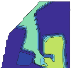
Fig. 13.6 Comparison of interpolation methods
The 'nearest neighbor' method delivers a completely different picture, as the
variable takes only two values. There is no transition zone. Concerning its geologi-
cal significance the result seems to be the closer to reality, as there are no locations
with intermediate values: the impermeable layer is either present or not.
There are also differences between the four methods concerning extrapolation.
Linear and cubic interpolation are based on triangulation of the model region and
thus deliver no values outside the subregion, for which data are available. Outside
that region
NaN
is given by the algorithm, i.e. there are no values extrapolated.
Consequently in these regions, near the upper and right boundary, no colours are
depicted in the plot. The other two methods deliver values for the entire grid,
although extrapolation may not be justified. By using the 'nearest neighbor'
method, the user has to set NaN's manually before plotting, if extrapolation is
not wanted.
References
Sandwell DT (1987) Biharmonic spline interpolation of Geos-3 and Seasat altimeter data.
Geophys Res Lett 14(2):139-142