Geography Reference
In-Depth Information
Dispatched
Incidents /
Resources
Waiting
Incidents /
Alerts
Electronic
Map
Phone
system
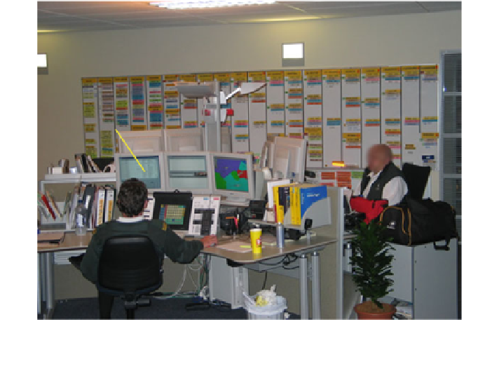
Fig. 3 Cluster of three dispatcher stations at NRCC with whiteboard in background, allowing
dispatchers to easily share information when required. Components of dispatcher CAD system
are labelled (adapted from Hayes
2006
)
5.2 The NRCC Displays
The dispatch system used by the dispatchers comprises three screens. The first
screen displays information regarding the status of incidents and the status of
ambulances. The second screen is usually configured to show waiting incidents
and alerts, such as when a report from a crew at the scene of an incident is overdue.
The third screen is an electronic map that dynamically shows ambulance and
ambulance station locations (Fig.
3
shows the in-office setup; Fig.
4
shows the
map screen).
When compared to the SRCC, there is a more advanced level of computer
support and capability in the NRCC, exhibited by the provision of an electronic
dynamic map directly to each of the dispatchers there. The various snapshots of the
NRCC map consist of street line data (augmented with land/sea and administrative
district areas) superimposed with point locations/labels of unallocated incidents,
ambulance stations, hospitals, standby points and ambulances of varying status,
e.g. on station, assigned to a job—in which case the journey start and end time is
specified; or at an incident. The clutter of information that can occur on-screen can
lead to difficulties with regard to extracting pertinent information from the display
in a timely manner. This is just one of the sources of complexity facing the
ambulance dispatcher. Therefore, a study was carried out to compare the existing
display with a map modified for display using a novel two-layer screen. The
splitting of information into two channels would theoretically reduce clutter.