Geography Reference
In-Depth Information
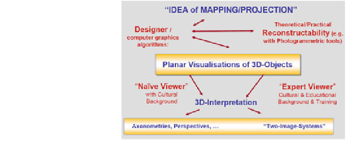
Fig. 1 Visualisation and
interpretation of 3D scenes
based on planar visualisations
of 3D objects (from Weiss
and Buchroithner
2012
)
with cartographic depictions this is an issue which still awaits more in-depth
research, aimed at answering the question: to what degree the relief intensity of a
landscape determines the possible aesthetics of a map, and—vice versa—how the
method of relief representation in a map may bias the aesthetic appearance of the
latter. We believe that the level of aesthetics of a cartographic product also
facilitates the user's generation of her/his mental (''cognitive'') map.
Regardless of these aspects of relief aesthetics, the question of how to optimally
convey the cartographer's ''3D message'' remains. Figure
1
describes the process
from an idea of the ''map maker'' to its spatial interpretation by the viewer via a
planar representation. In this regard the designer has to consider that an expert
viewer ''reads'' and interprets a 3D scene in a different way than a ''naïve'',
inexperienced viewer does. The planar visualisation of physical three-dimensional
objects is the link between the concepts, algorithms and in general the recon-
structability by means of computer graphics and/or photogrammetric tools on one
side and the mental reconstruction and, further, interpretation on the other side. It
is a model for the 3D object.
A difficult situation arises where, besides the relations between positions of
points and objects in Euclidean space, there are hidden and obvious assumptions
packed into a visualisation. The viewer interprets the visualisation after having put
it into a certain context, be it the explicit verbal description of what should be seen
in the picture, or the viewer's own knowledge or imagination. Of course, these facts
also rule visualisations in Cartography (Weiss and Buchroithner
2012
, Fig.
2
).
In summary, the theory behind the aforementioned aspects of stereovision of
geo-scenes is rather complicated (see Fig.
2
) and by no means resolved, both in
terms of methodological structuring and terminology. To this end, the present
paper only represents the interim state of developments which are in a state of flux.
The reader is kindly referred to the paper by Weiss and Buchroithner
2012
.
Furthermore, a more comprehensive treatment of the theory and technology
regarding the field of ''true 3D cartography'' by the authors of this article (Knust
and Buchroithner
2012
) as well as an overview of the role of true-3D visualisation
in cartography (Buchroithner and Knust
2012
) is in preparation.