Geography Reference
In-Depth Information
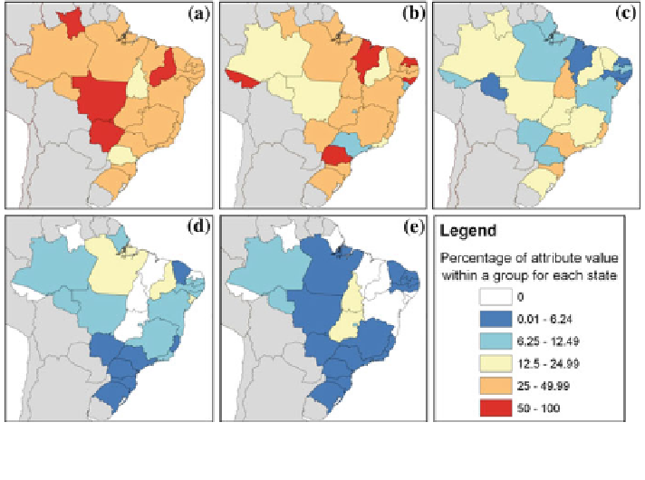
Fig. 4
The Brazilian states mapped by crime type (as
% for state): a Robbery; b Violence;
c Theft; d Attempted robbery; e Attempted theft
3.1.1 Initial Data Processing
Spatially, WikiCrimes collects data on crimes that are considered to occur at points
in space. However, eXplorer only maps attribute data by polygon as a choropleth
map and this implies a process of aggregation to move from one environment to
the other (indeed, it is this generalization that marks the approach written about
here). This matches Elwood's (
2009
) characterization of volunteered geographic
information (VGI). The WikiCrimes dataset forms an integrated large resource of
individual volunteered data whilst the geovisual analytic activities proposed with
eXplorer adds further query, retrieval and analysis capabilities that Elwood
prescribes for VGI (the shifting nature and heterogeneity of such data is also
acknowledged and discussed in the conclusion).
Each record in WikiCrimes is tagged by either Brazilian state/country (choro-
pleth), or by degree grid square, and this facilitates aggregation (see Fig.
3
). Even if
this didn't occur, it would be simple to perform a spatial join with the polygon
boundaries (of country and Brazilian state boundaries) or grid cell boundaries and
crime points. For each crime variable, Brazilian states or grid cells were summarized
by count of records. Finally, since the number of crimes was heavily weighted
towards the Ceará and Fortaleza area, each variable was normalized as a percentage
of their variable group (a non-area-related ratio map—Kraak and Ormeling
2010
).
To illustrate, consider bank-related crime such as armed robbery. In the WikiCrimes
database, the bank is recorded as a crime setting along with other types of places such
as thoroughfares, homes and even vehicles. The number of crimes occurring in any