Geoscience Reference
In-Depth Information
A
B
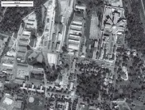
Figure 3-17.
Ikonos false-color composite of Fort
Leavenworth, northeastern Kansas, United States (see
Color Plate 3-17). Green, near-infrared and red bands
color coded as blue, green and red; active vegetation
appears dark green to yellow-green colors. Dataset
acquired August 2000; compare with Figure 3-16.
Image from NASA; processing by J.S. Aber.
is highly desirable for wetland imagery (Fig.
3-17). The main drawback for this type of data
is its high commercial cost, which amounts to
several thousand US dollars per scene, com-
pared with essentially free DOQ, Landsat, and
other data types. Google Earth provides high-
resolution imagery for many parts of the world,
which is quite valuable for general geography;
however, metadata are not given, which limits
the usefulness of such images for detailed inter-
pretation purposes.
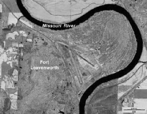
Figure 3-16.
Digital orthophotographs of Fort
Leavenworth, northeastern Kansas, United States. A.
Four DOQs were concated together to create this
mosaic. The tile boundaries are most obvious in the
Missouri River because of different lighting conditions.
B. Close-up view of the central fort complex. The
star-shaped building in upper right corner is the former
disciplinary barracks (military prison). Note the level of
detail visible in this scene. Image processing by J.S.
Aber.
3.2.5 Micro-level systems
To reach the micro level of wetland research,
GSD
<
(Fig. 3-16). A parallel trend is replacement of
conventional aerial cameras employing large-
format i lm by digital aerial cameras with similar
spatial resolution.
Beginning in 1999 with Ikonos, high-
resolution commercial satellites have provided
imagery with GSD of 1-4 m and, most recently,
as small as half a meter (Tatem, Goetz and
Hay 2008). This spatial resolution rivals conven-
tional airphotos and DOQs. These satellites also
provide multispectral capability, typically in
blue, green, red, and near-infrared bands, which
10 cm is necessary. This can be achieved
through small-format aerial photography (SFAP).
Manned or unmanned platforms include ultra-
lights, paragliders, balloons, blimps, model air-
planes, kites, and other aircraft that typically l y
at heights of just a few hundred meters (Aber,
Marzolff and Ries 2010). Many types of i lm or
digital cameras may be utilized to acquire pho-
tographs in visible and near-infrared portions of
the spectrum. We have used kites and a small
helium blimp extensively to document wetlands
in many settings (Fig. 3-18 and Fig. 3-19).