Geoscience Reference
In-Depth Information
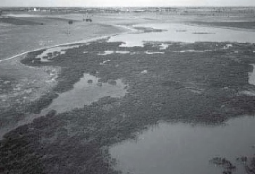
A
B
Figure 16-17.
Cattails at Nature Conservancy marsh, Cheyenne Bottoms, Kansas (see Fig. 13-2 for location). A.
Healthy cattail thickets (dark gray) cover much of the marsh prior to drought. This phase represented the culmination
of cattail expansion during the previous decade of relatively wet, cool climatic conditions. View westward with
Hoisington in the background. Image date May 2002. B. View toward northwest over partially dead cattail thickets
(light gray) following drought. Small patches and narrow zones of cattails survived (dark gray), particularly around
the margins of thickets. Image date June 2003. Kite aerial photographs by J.S. Aber and S.W. Aber.
Drought conditions soon returned, and by
the autumn of 2006 the marshes were com-
pletely dry. TNC now conducted extensive
disking of dry mud l ats and mowing of cattail
thatch in an attempt to mimic heavy bison
grazing (Fig. 16-18). Wet conditions quickly
returned in 2007 with l ooding of historic mag-
nitude at Cheyenne Bottoms (Fig. 16-19). Much
of the bottoms was inundated for several
months. A multitemporal Landsat image illus-
trates the dramatic changes in water bodies,
vegetation, and other land cover between 2006
and 2009 (Fig. 16-20). This image also highlights
the deltas built by Deception and Blood creeks
respectively in the northern and western por-
tions of the bottoms. These deltas remained
above most of the 2007 l ooding; whereas nearly
all the state wildlife area was submerged, and
TNC marshes were inundated in the embayment
between the two deltas.
As the impact of l ooding receded, a bloom
of mosquito fern (
Azolla
sp.) took place in TNC
marshes in 2009 (Fig. 16-21A). This was remark-
able because such a bloom had not been
observed before in TNC marshes (see Color
Plate 6-11). Widespread l ooding in 2007 is con-
sidered the most likely means for transporting
Azolla
spores or plant fragments into TNC
marshes. Several other dispersal mechanisms
are possible, however, including waterfowl,
boats and i shing equipment, or sewage dis-
charge. Regardless of how
Azolla
entered TNC
marshes, it had nearly disappeared by the fol-
lowing year (Fig. 16-21B), and cattail became
dominant again the next year (Fig. 16-22). This
discussion demonstrates the dynamic and highly
variable wetland conditions of TNC marshes at
Cheyenne Bottoms.
In addition to its environmental importance,
Cheyenne Bottoms has a signii cant impact on
the local and state economy, primarily through
hunting and bird watching, which bring in state
hunting fees as well as money spent locally for
lodging, food, and supplies. In recognition of
the economic impact of tourism, the Kansas
Wetland Education Center was constructed in
2007-08 and opened to the public in 2009 (see
Fig. 16-16). The center is a cooperative venture
of the Kansas Department of Wildlife and Parks,
which owns the land, and Fort Hays State Uni-
versity, which operates the center. Other part-
ners include Ducks Unlimited and the City of
Great Bend. In addition, the Wetlands and Wild-
life National Scenic Byway links Cheyenne
Bottoms to Quivira National Wildlife Refuge,
another Ramsar Wetland of International Im-
portance south of the Arkansas River (see Fig.
11-19).