Geoscience Reference
In-Depth Information
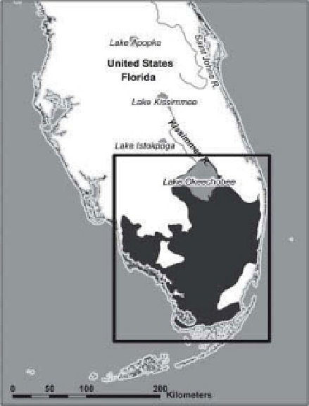
A
B
Figure 15-11.
Florida peninsula. A. Oblique manned-space photograph looking northward over the Florida
Peninsula. Adapted from NASA Johnson Space Center; STS51C-44-26; January 1985. B. Map of southern Florida; the
Everglades drainage system is depicted in dark gray. Produced by A. Dailey. Map made with data from Natural
Earth, Global Administrative Areas, and World Wildlife Fund Terrestrial Ecoregions Database (Olson et al. 2001).
Accessed online
<
www.naturalearthdata.com
>
<
http://www.gadm.org/
>
and
<
http://www.worldwildlife.org/science/
data/item6373.html
>
February 2011. See also Fig. 3-13.
delta, which has suffered much during hurri-
canes of recent years; and Padre Island and
Laguna Madre of South Texas. Water chemistry
and sediment input vary greatly among these
sites, but all are heavily impacted by past and
present human activities. Many portions of these
sites are protected in various national parks, sea-
shores, wildlife refuges, and nature preserves.
of the water-l ow system. Immediately to its
north is Big Cypress National Preserve. Con-
tinuing to Lake Okeechobee is a series of
surface-water storage conservation areas that
were established along the Shark River Slough
to control and distribute water throughout
southern Florida (Fig. 15-13). Prior to human
drainage and development, the Everglades was
one of the largest fresh-water marsh systems
in the world, covering some 10,000 km
2
(4000
square miles), but less than half this area remains
nowadays (Dugan 2005).
The climate of the Everglades region is semi-
tropical, and palms and tropical plants co-exist
alongside warm-loving temperate vegetation.
The region experiences two main seasons
-
wet
(summer) and dry (winter). The hurricane
season is mainly in summer and early autumn,
when sea-surface temperature is warmest, and
drought conditions may develop some years in
spring. Water drainage from Lake Okeechobee
15.5.1 Florida Everglades
The Florida Everglades is a vast expanse of wet
sawgrass prairie that extends from Lake Okee-
chobee in south-central Florida to the man-
groves along the coast of southern Florida (Fig.
15-11). Lake Okeechobee is the upstream source
of surface water, which migrates slowly as
shallow sheet l ow over a l at limestone plateau
that slopes imperceptibly southward to the sea.
Everglades National Park, established in 1947
(Fig. 15-12), occupies the downstream portion