Geoscience Reference
In-Depth Information
Few coordinated conservation efforts exist
between India and Bangladesh. The two coun-
tries have several long-standing issues, which
include disputes over the extraction, diversion
and allocation of waters from the Ganges and
its tributaries upstream from Bangladesh. Mean-
while the diversion of fresh water and migration
of the river channels farther eastward have
caused higher salinity gradients in the western
portion of the mangroves. This has affected
local l ora and fauna, as reported in the case of
localized die-backs of
Heritiera fomes
(Interna-
tional Union for Conservation of Nature 1997).
The Sundarbans region clearly faces signii cant
challenges in the twenty-i rst century. Meeting
these will require striking a balance between
growing human needs and allowing ecosystem
functions to perform. These challenges undoubt-
edly will be compounded by Indo-Bangladeshi
politics and the regional ramii cations of global
climate change on sea levels, storm activity, tem-
peratures, and precipitation regimes.
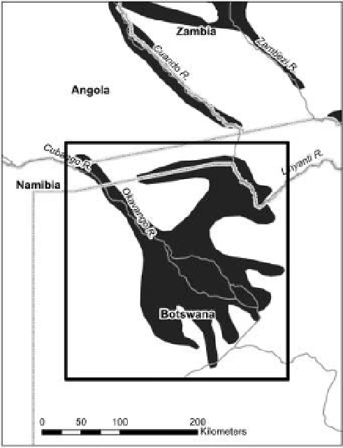
Figure 15-4.
Map of the Okavango Delta wetlands and
surrounding region of southern Africa. Produced by A.
Dailey. Map made with data from Natural Earth, Global
Administrative Areas, and World Wildlife Fund
Terrestrial Ecoregions Database (Olson et al. 2001).
Accessed online
15.3 Okavango Delta of southern Africa
North of the Kalahari Desert in southern
Africa lies one of the largest seasonally l ooded
inland deltas in the world. The Okavango Delta
is located at 18°45
<
www.naturalearthdata.com
>
<
http://
>
<
www.gadm.org/
http://www.worldwildlife.org/
science/data/item6373.html
and
E lon-
gitude and is formed by the Okavango River,
which traverses more than 1000 km from the
Angolan highlands
-
slowly making its way
southeastward across the dry interior of south-
ern Africa. The river's l ow is dependent on
rainfall across its watershed and this water is
carried through Angola and Namibia and into
Botswana, where it eventually fans out into a
bird-foot-shaped alluvial delta (Fig. 15-4). The
narrow panhandle of the Okavango River as it
enters Botswana is formed by geological fault
lines that constrain the water's l ow to a con-
tained channel (Fig. 15-5). These faults found
across the region are an extension of the East
African Rift system. Farther downstream addi-
tional faults allow the river greater freedom to
branch out, which eventually leads it to distrib-
ute its water over a wide and relatively l at basin
underlain by deep sand deposits.
′
S latitude and 22°45
′
>
February 2011.
The river's l ood pulse brings life-sustaining
water to the delta during the height of the dry
season between May and September, when
water levels have fallen to critical levels across
much of the region. This provides a refuge for
wildlife, birds, domesticated cattle, and other
foraging animals. Total l ows into the delta
average 9.4 km
3
per year with annual variations
based on precipitation trends (Mendelsohn and
el Obeid 2004). The delta is also fed by local
rainfall averaging 490 mm during the summer
months starting as early as November and espe-
cially between January and March (McCarthy et
al. 2000).
During particularly wet periods, overl ow
from the delta may make its way farther south-
east via the ephemeral Boteti River to enter the