Geoscience Reference
In-Depth Information
contrast, hollows and pools are sites of methane
emission. Gradual changes in hummock-hollow
distribution, thus, affect methane l ux within the
bog system. A negative feedback relationship
exists, such that warm/dry weather causes an
increase in hummocks and ridges and thus a
reduction in methane emission. Reduced atmos-
pheric methane would, in turn, lead to a de-
creased greenhouse effect and cooler climate.
On this basis, it appears that bogs of the Baltic
region have the potential to dampen changes in
climate brought about by other factors.
These examples illustrate that connections
between climate and wetlands may become
quite complex. When multiple autogenic and
allogenic processes interact, the results may be
unexpected. Many natural and human factors
may inl uence the ability of wetlands to store
or release carbon, and predicting the impact of
climatic change on wetlands is a particularly
daunting task. The numbers of variables and
feedback relationships are simply too many, and
too little is known about them to reach any
convincing opinions about the future of wet-
lands and climate. Even the most basic climatic
inl uences, such as solar energy and volcanic
eruptions, are impossible to predict. While it
appears likely that the Earth's climate will con-
tinue to warm during the twenty-i rst century,
any attempt to model future global climate
change and its impact on wetlands is fraught
with uncertainty.
A
B
C
8.5 Fire
Fire is an integral part of many ecosystems, and
humans have set i res since ancient times for
hunting, warfare, clearing forests, burning agri-
cultural waste, and other purposes (Fig. 8-29).
Prescribed burning is used routinely by the U.S.
National Forest Service and other agencies for
habitat maintenance. Controlled i re is essential
for preserving the tallgrass prairie in the Flint
Hills of eastern Kansas (Applegate, Flock and
Finck 2003). Prairie i re renews the grass, inhib-
its trees and woody vegetation, and returns
nutrients to the soil (see Color Plate 6-37). Pre-
scribed burning has likewise been used to
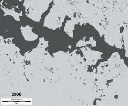
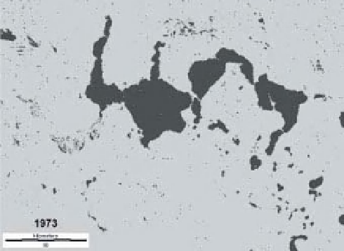
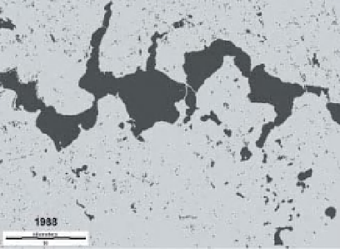
Figure 8-27.
Expansion of Devils Lake based on
Landsat MSS and TM imagery. Devils Lake itself
(excluding smaller, unconnected lakes) more than
tripled in area from 122 km
2
in 1973, to 186 km
2
in
1988, to 372 km
2
in 2000. Image from NASA; analysis
by J.S. Aber.