Geoscience Reference
In-Depth Information
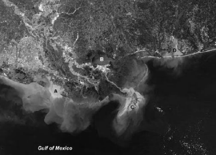
Figure 8-13.
Natural-color satellite image of the Mississippi Delta region showing distinct sediment plumes in the
Gulf of Mexico (see Color Plate 8-13). The Mississippi River delivers about 500 million tons of sediment into the gulf
annually via the main stem of the river and its Atchafalaya distributary. A. Atchafalaya Delta, B. Lake Pontchartrain,
C. Mississippi Delta, D. Mobile Bay. New Orleans is the light patch on the southern side of Lake Pontchartrain.
MODIS image acquired 5 March 2001; adapted from NASA Visible Earth
<
http://visibleearth.nasa.gov/
>
.
As noted above, the relative position of sea
level along any particular coast depends on both
eustatic changes and local land movements.
Many coastal environments are sinking or
retreating due to a combination of local factors
-
sediment compaction, shore erosion, reduced
sediment supply, crustal subsidence, subsurface
solution, etc. Local land sinking plus global eus-
tatic rise add up to substantial rates of sea-level
increase in many localities. Galveston, Texas, for
example, experienced a relative sea-level rise of
6 m (20 feet) during the twentieth century at a
relatively constant rate of 6 cm per year (Pilkey
and Young 2009).
For low-lying coasts that slope gently into
shallow seas, a small increase in sea level would
result in a large inland migration of the shore,
and substantial erosion would take place in
unconsolidated sediments. The North Sea coast
of northwestern Denmark illustrates these con-
sequences dramatically (Fig. 8-14). Coastal cliffs
stand tens of meters high and are composed of
unconsolidated mud, sand and gravel sediments
left by the last glaciation of the region (Fig.
8-15). Historic structures
-
farms, villages,
churches
-
built during the Middle Ages hun-
dreds of meters back from the cliff are now
falling into the sea (Fig. 8-16). The long-term
rate of cliff retreat is on the order of one meter
per year (H. Lykke-Andersen, pers. com. 2005).
A large volume of eroded sediment is trans-
ported northward by longshore drift and has,
over millennia, built out the Skagen peninsula
as a huge sand spit (Fig. 8-17).
Clearly, coastal processes are removing sedi-
ment and land in some sectors and building new
land in other places. The debate about what to
do has been settled in Denmark with the deci-
sion that nature should run its course in most
places. Nonetheless, some historical structures
have been protected from further coastal erosion
(Fig. 8-18). Similar situations exist in many other
coastal settings. Another famous case is the
Cape Hatteras Lighthouse built on the Outer
Banks of North Carolina in 1870. At that time,
it was half a kilometer inland and well above
mean sea level (Pilkey and Young 2009). It took
just over a century of erosion and land loss