Geoscience Reference
In-Depth Information
soaking up excess water, recharging aquifers,
and then releasing surface water slowly. Thus,
the pulse of l ood water is spread over a longer
time period, so the downstream l ood peak is
lowered. Furthermore, l ood water stored tem-
porarily in wetlands and then released gradually
is cleansed of much sediment and debris.
In the summer of 1993, the upper Mississippi
drainage basin experienced major l oods, affect-
ing the upper Mississippi, lower Missouri,
Kansas, Des Moines, Illinois, and other rivers.
Millions of acres of farmland and urban areas
were inundated for weeks, and property damage
exceeded $10 billion (Parrett, Melcher and James
1993). Persistent rains fell throughout much of
the region during the spring and summer. Most
of the region received 150 percent of normal
precipitation, and some spots had more than
200 percent of normal rainfall (Melcher and
Parrett 1993).
Peak discharges were all-time records on
many rivers, and other rivers recorded the great-
est discharges since the time their l ows had
been regulated by reservoirs and canals. Prior
to the 1993 l oods, it is estimated that l ood-
water storage capacity of the Mississippi River
had been reduced by up to 80 percent, because
of loss of forested wetlands and coni nement by
levees (Gosselink et al. 1981). The inability to
absorb excess water undoubtedly exacerbated
l ooding, which was unusual because of its
widespread and long-lasting nature (Larsen
1996). At Saint Louis, the Mississippi River
exceeded l ood stage on 26 June, reached its
peak discharge of 1,080,000 cfs on 1 August
(Parrett, Melcher and James 1993), and remained
in l ood until mid-August (Fig. 4-16). The mag-
nitude of peak l oods would probably have been
much higher without substantial regulation of
stream l ow. On the other hand, the long dura-
tion of l ooding was probably caused in part by
stream regulation.
Management of l ood-control reservoirs is
to reduce downstream peak discharge by
spreading the l ow over longer time intervals.
Many dikes, levees, and small dams failed during
these l oods. However, large structures of the
U.S. Army Corps of Engineers functioned prop-
erly without serious failures, although some
A
B
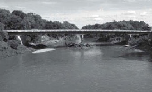
Figure 4-15.
Impact of bridges on l ooding. A.
Traditional double-arch stone bridge on Rock Creek in
south-central Kansas. As water level rises, l ow width
under the bridge decreases, which exacerbates l ooding
around the bridge. B. Modern bridge design on the
Cottonwood River at Emporia, Kansas. As water level
rises, l ow width under the bridge increases to
accommodate greater discharge. Photos by J.S. Aber.
in soils, land slopes, drainage, surface cover, and
other attributes that affect water ini ltration,
runoff, l ow rate, residence time, and other
hydrologic factors. A simple example is building
bridges, something people do everywhere (Fig.
4-15). In fact, just about every kind of human
activity results in some sort of hydrologic impact.
Such changes may benei t certain segments
of society while proving deleterious for other
economic or recreational interests. Thus, imple-
menting stream and river control is a complex
societal issue in the modern world. As noted
before, human activities have led to substantial
decreases in wetlands worldwide. Nonetheless,
l oodplain wetlands often play a signii cant role
for lessening the impact of downstream l ood-
ing. Wetlands function essentially as sponges,