Environmental Engineering Reference
In-Depth Information
To reduce the threat of flooding and thus to allow
people to live in floodplains, rivers have been nar-
rowed and straightened (channelized), equipped with
protective levees and walls, and dammed to create
reservoirs that store and release water as needed. In
the long run, however, such measures can greatly in-
crease flood damage because they can be over-
whelmed by prolonged rains, as happened along the
Mississippi River in the midwestern United States
during the summer of 1993 (Figure 11-22).
People settle on floodplains because of their many
advantages, including fertile soil, ample water for irri-
gation, availability of nearby rivers for transportation
and recreation, and flat land suitable for crops, build-
ings, highways, and railroads.
Floods are a natural phenomenon and have
several benefits. They provide the world's most pro-
ductive farmland thanks to the nutrient-rich silt left
behind after floodwaters recede. They also recharge
groundwater and help refill wetlands.
Unfortunately, each year floods kill thousands of
people and cause tens of billions of dollars in property
damage. Floods, like droughts, usually are considered
natural disasters. Since the 1960s, however, human ac-
tivities have contributed to the sharp rise in flood
deaths and damages.
One such activity is
removal of water-absorbing vege-
tation,
especially on hillsides (Figure 11-23). Another is
draining wetlands
that absorb floodwaters and reduce
the severity of flooding.
Living on floodplains increases the threat of dam-
age from flooding. Flooding also increases when we
pave or build, and replace water-absorbing vegetation,
soil, and wetlands with highways, parking lots, and
buildings that cannot absorb rainwater.
In developed countries, people deliberately settle
on floodplains and then expect dams, levees, and other
devices to protect them from floodwaters. When heav-
ier-than-normal rains occur, these devices can be over-
whelmed. In many developing countries, the poor
have little choice but to try to survive in flood-prone
areas (see the following Case Study).
Learn more about how cutting a forest can change
the surrounding land and the weather at Environmental
ScienceNow.
Science and Poverty Case Study: Living
on Floodplains in Bangladesh
Bangladesh has experienced increased flooding
because of upstream deforestation of Himalayan
mountain slopes and the clearing of mangrove forests
on its coastal floodplains.
Bangladesh is one of the world's most densely popu-
lated countries, with 144 million people (projected to
reach 280 million by 2050) packed into an area roughly
the size of Wisconsin. It is also one of the world's poor-
est countries.
The people of Bangladesh depend on moderate an-
nual flooding during the summer monsoon season to
grow rice and help maintain soil fertility in the delta
basin. The annual floods deposit
eroded
Himalayan
soil
on
the
country's crop fields.
In the past, great floods oc-
curred every 50 years or so. Since
the 1970s, however, they have
come roughly every 4 years.
Bangladesh's flooding problems
begin in the Himalayan water-
shed, where several factors—
rapid population growth, de-
forestation, overgrazing, and un-
sustainable farming on steep and
easily erodible slopes—have
greatly diminished the ability of
its mountain soils to absorb
water.
Think of a forest as a com-
plex living sponge for catching,
storing, using, and recycling
water and releasing it in small
amounts. Cut down the forests
on the Himalayan mountains
and what happens? Instead of be-
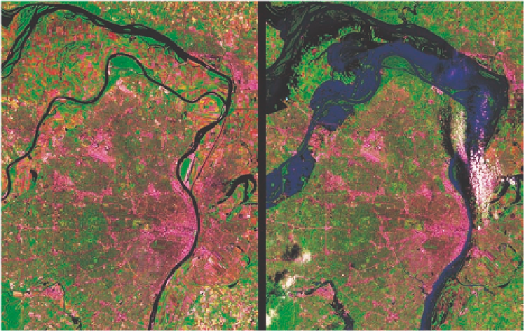
Figure 11-22
The satellite image on the left shows the area around St. Louis, Missouri, on July 4,
1988, under normal conditions. The image on the right shows the same area on July 18, 1993,
after severe flooding from prolonged rains. Note the large increase in the flooded (blue) area.