Environmental Engineering Reference
In-Depth Information
10.3.2
A Peruvian
forest successional
mosaic - patching a
living together
Primary forest in tropical Peru has traditionally been cut down to make way for
pasture and agriculture. After some years these patches are left fallow and begin
their succession to secondary forest, but later they may be cleared again. The result-
ing successional mosaic (defi ned in Box 8.1) contains patches with different harvest
values, and local people can weigh up the options of further clearing or of harvest-
ing forest products. Gavin (2004) gathered ecological and sociological data from
families with rights to a mixture of agricultural land, fallow fi elds, young secondary
forest and old secondary forest patches in Peru's Cordillera Azul region.
Of all the successional stages, old secondary forest contained the largest number
of species of useful plants and animals and also more species found at no other
successional stage, including large-bodied mammals such as tapirs (
Tapir u s
terres-
tris
) and armadillos (
Priodontes
maximus
). Fallow fi elds and young forests yielded
mainly small-bodied birds and rodents, as well as fi shes. Food (both animals and
plants), wood and medicines were the most valuable commodities from all vegetation
types, but their relative importance varied with successional stage (Table 10.1), and
their availability, use and perceived value contrasted dramatically from family to
family.
If farmers in this area want to maximize land value while maintaining access
to all necessary forest products, Gavin suggests they should manage their forest-
clearing and fallow cycles to encourage the greatest possible range of patches of
different ages. The families will take into account also that the older the forest patch
the more fertile it will be when cleared, but more effort has to be expended to clear
larger trees. And it has to be borne in mind that median values for agricultural
products on cleared land are much higher than for forest products (e.g. $167 ha
−1
yr
−1
for coffee). Gavin's work highlights the range of information needed for a systematic
approach to landscape harvest management.
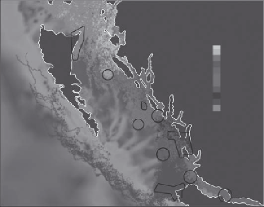
Fig.
10.7
Simulated
spread on ocean
currents along the
north Pacifi c coast of
Canada of particles
introduced at a depth of
2 m to represent fi sh
larvae, from each of ten
marine protected areas
(out lined in white) over
a 90-day period.
Particles from each
protected area are
shown in a unique color
(see key). Grey areas
represent Vancouver
Island and the
Canadian mainland.
The continental shelf is
shown in pink. NK,
Naikoon; BISR, Banks
Island sponge reef; BY,
Byers; MBSR, Middle
Bank sponge reef; LS,
Laredo Sound; GIB,
Goose Island Bank; HK,
Hakai; SI, Scott Islands;
QCS, Queen Charlotte
Sound; BS, Blackfi sh
Sound. (After Robinson
et al., 2005.) (This
fi gure also reproduced
as color plate 10.7.)
NK
BISR
MBSR
GIB
B
QCS
L
B
HK
S
NK
BISR
BY
LS
MBSR
HK
GIB
QCS
SI
BS


Search WWH ::

Custom Search