Travel Reference
In-Depth Information
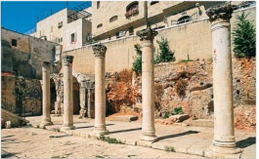
The Cardo
1
Map
3 C4.
On the building next to
the exposed wall, a clearly
visible line indicates what
archaeologists think was the
original height of the wall.
Also visible are the remains
of housing from the same
period, demolished to make
way for the wall, as described
in the Book of Isaiah (22: 10),
“And ye have numbered the
houses of Jerusalem, and the
houses have ye broken down
to fortify the wall”.
Now in part an exclusive
shopping arcade, the Cardo
was Jerusalem's main
thoroughfare in the Byzantine
era. It was originally laid by
the Romans, then extended
in the 4th century as Christian
pilgrims began to flock to
Jerusalem and the city
expanded accordingly. The
Byzantine extension, which
remains in evidence today,
linked the two major places
of worship of the time, the
Church of the Holy Sepulchre
(see pp92-7)
in the north and
the long-since-vanished Nea
Basilica
(see p82)
in the south.
The central roadway of the
Byzantine Cardo was 12.5 m
(41 ft) wide. This was flanked
by broad porticoed pavements
and lined with shops. Visitors
can get a good idea of how
the area once looked by
descending to a reconstructed
section, which runs for almost
200 m (650 ft) alongside
Jewish Quarter (Ha-Yehudim)
Y
Road. At the southern end
are the remains of original
shops that were partly hewn
out of the rock on the west
side of the street.
The Cardo's continued
importance during the reign
of Justinian in the 6th century
is attested to by its prominent
appearance on the famous
Madaba map
(see pp216-17)
.
Some 500 years later, in the
Crusader era, the Cardo was
converted into a covered
market, which is how the
northern section has now been
preserved, as an arcade of
smart galleries and boutiques.
Hurva Square
3
Map
3 C4.
The Broad Wall, part of the city's
8th-century BC fortifications
This is the heart and social
centre of the present-day
Jewish Quarter. In the maze
of narrow, winding streets
which, though modern,
follow the topography of the
quarter before its destruction,
Hurva Square is one of the
few open spaces in the
area. It has cafés, souvenir
shops and a few snack
bars that have small tables
outside when the weather
is good. Also here is
the
Jewish Students'
Information Centre
,
which provides help
with accommodation
and invitations to
Shabbat (Sabbath)
dinners for visiting
young Jews.
On the west
side of the square
is the minaret of
the long-since vanished 14th-
century Mameluke
Mosque
of Sidna Omar
, along with the
historic Hurva and Ramban
synagogue complexes. Hurva
means “ruins” and the history
of the
Hurva Synagogue
more
than justifies its name. In the
18th century a group of a few
hundred Ashkenazi Jews from
Poland came to Jerusalem
and founded a synagogue
on this site. However, it was
burnt down by creditors
angered by the community's
unpaid debts. The synagogue
was rebuilt in 1864 in a Neo-
Byzantine style. However,
during the fighting that took
place in 1948 between the
Arab and Jewish armies, the
synagogue was destroyed.
After the Israelis recaptured
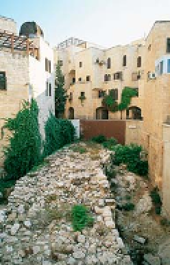
The Broad Wall
2
Plugat ha-Kotel Street.
Map
3 C4.
The Jewish quarter was
largely destroyed during the
1948 War and allowed to
deteriorate further under
Jordanian occupation.
Following the 1967 Israeli
victory, a vast recon-
struction programme
resulted in many signif
icant archaeological
finds. One of these
was the unearthing
of the foundations
of a wall 7 m (22 ft)
thick and 65 m (215
ft) long. This was
possibly part of
fortifications built by
King Hezekiah in the
8th century BC to
enclose a new quarter outside
the previous city wall. The
need for expansion was
probably brought about by
a flood of refugees after the
Assyrian invasion of 722 BC.
Sidna Omar minaret
The Cardo, the main street of Byzantine-era Jerusalem