Travel Reference
In-Depth Information
Sodom
q
Road map
C4. Route 90, 50 km
(31 miles) S of Ein Gedi.
@
from
Jerusalem.
stopover on the trade route
between Egypt and Asia
Minor. It continued to prosper
under the Byzantines, and
most of what you see today
dates from the 4th or 5th cen-
tury, including the remains
of houses, baths and two
churches. The smaller of
these has its original apse
and bishop's throne; a white
line divides the original and
reconstructed parts. The
views across the desert are
excellent. Below the hill you
can make out evidence of the
network of dams built by the
Nabataeans to channel rain-
water towards the dry land,
enabling them to plant vine-
yards and fruit orchards.
Ovdat was abandoned after
the Persian invasion of 620.
The Visitors' Centre has an
exhibition of archaeological
finds from the ancient site.
Biblical tradition holds that
the city of Sodom lay on the
southern shore of the Dead
Sea (Genesis 19). Its sinful
inhabitants, along with those
of neighbouring Gomorrah,
angered God, and he
destroyed the cities with
“brimstone and fire”.
Archaeologists now favour
Bab ed-Dhra in Jordan as
the likely site, but the name
Sodom remains attached to a
spot on the Israeli side of the
Dead Sea. There is nothing
to visit but nearby are the
two spas of
Ein Bokek
and
Neve Zohar
, famous for their
therapeutic centres, and a
public beach with fresh-water
showers
(see p197)
.
Inland and 9 km (6 miles)
south of Neve Zohar is
Mount Sodom
, a mountain
composed largely of rock salt.
A well-marked path goes up
to the top, from where you
can enjoy incomparable views
of the Dead Sea and the
Moab mountains in Jordan.
You can also go up by car:
take the dirt road that heads
west off route 90 just north
of the unattractive Dead Sea
Works plant. Another sign-
posted scenic hiking route
leads to what is known as the
Flour Cave
. The cave gets its
name from the white crumbly
chalk coating that covers the
interior and the clothing of
all who visit.
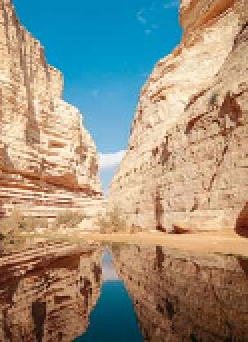
Spring-fed pool at Ein Ovdat in the
shade of canyon walls
Ein Ovdat
w
Road map
B5. Route 40, 52 km
(32 miles) S of Beersheva.
Tel
(08)
l
655 5684.
@
from Jerusalem.
#
summer: 8am-4pm (3pm Fri &
hol eves); winter: 8am-3pm (2pm Fri
& hol eves) daily.
&
At Ein Ovdat a white-walled
gorge gouged 200 m (656 ft)
deep into the desert floor
shades two icy-cold pools.
The larger of the pools is fed
by a waterfall with its source
in the rock face high above.
Archaeologists have found
traces of human presence
in this area that date back
perhaps 35,000 years,
suggesting that the springs
were known in antiquity.
A well-marked trail through
the gorge begins at a roadside
viewpoint 2 km (1 mile) south
of the turn-off for Kibbutz
Sde Boker. The trail ends with
a set of rough rock-cut steps
ascending the cliffs; the views
from these back down the
gorge are spectacular. From
the clifftop a path leads to
a roadside car park 7 km (4
miles) south of the viewpoint.
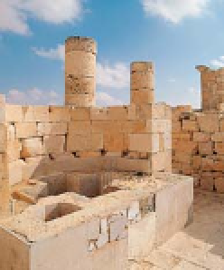
Partially reconstructed Byzantine-
era ruins at Ovdat
Hebron
r
Road map
B4.
*
120,000.
@
(
daily.
Nestled among hills 40 km
(25 miles) south of Jerusalem,
Hebron is one of the most
densely populated towns in
the West Bank. Its fame rests
on its glassmaking, which
began in the Middle Ages and
has always been managed by
one single family.
This coloured glassware
can be found for sale in
another of Hebron's major
attractions, its medieval Arab
souk, which contains some
imposing Crusader-era
vaulted passageways.
However, Hebron is a town
undermined by troublesome
political tensions. It is divided
Ovdat
e
Road map
B5. Route 40, 60 km
(37 miles) S of Beersheva.
Tel
(08)
l
655 1511.
@
from Jerusalem.
#
summer: 8am-4pm (3pm Fri
& hol eves); winter: 8am-3pm (2pm
Fri & hol eves) daily.
&
Located on a flat hilltop,
the ancient town of Ovdat
was built by the Nabataeans
in the 2nd century BC as a
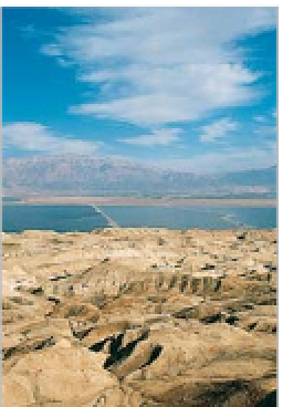
A typically barren Dead Sea
landscape near Sodom
For hotels and restaurants in this region see pp261-2 and pp278-9